Long Island, Maine
| Long Island, Maine | ||
|---|---|---|
| Town | ||
|
||
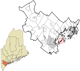
 Location in Cumberland County and the state of Maine. |
||
| Coordinates: 43°41′34″N 70°9′17″W / 43.69278°N 70.15472°W | ||
| Country | United States | |
| State | Maine | |
| County | Cumberland | |
| Incorporation | July 1, 1993 | |
| Area | ||
| • Total | 33.52 sq mi (86.82 km2) | |
| • Land | 1.42 sq mi (3.68 km2) | |
| • Water | 32.10 sq mi (83.14 km2) | |
| Elevation | 14 ft (4 m) | |
| Population (2010) | ||
| • Total | 230 | |
| • Estimate (2012) | 234 | |
| • Density | 162.0/sq mi (62.5/km2) | |
| Time zone | Eastern (EST) (UTC-5) | |
| • Summer (DST) | EDT (UTC-4) | |
| ZIP code | 04050 | |
| Area code(s) | 207 | |
| FIPS code | 23-41067 | |
| GNIS feature ID | 1729676 | |
| Website | www |
|
Long Island is an island town in Cumberland County, Maine, United States, which seceded from the city of Portland in 1993. The population was 230 at the 2010 census. It is part of the Portland–South Portland–Biddeford, Maine Metropolitan Statistical Area.
According to the United States Census Bureau, the town has a total area of 33.52 square miles (86.82 km2), of which, 1.42 square miles (3.68 km2) of it is land and 32.10 square miles (83.14 km2) is water.
The total population of 202 only includes year-round residents. A significant number of seasonal residents causes the population to swell to over 700 during the summer. There are 175 registered voters on Long Island.
Long Island maintains its own elementary school from grades K-5, but sends students to Portland for schooling from grades 6 through 12.
As of the census of 2010, there were 230 people, 99 households, and 70 families residing in the town. The population density was 162.0 inhabitants per square mile (62.5/km2). There were 381 housing units at an average density of 268.3 per square mile (103.6/km2). The racial makeup of the town was 93.5% White, 2.2% African American, 0.4% Native American, 2.6% Asian, 0.4% from other races, and 0.9% from two or more races. Hispanic or Latino of any race were 2.2% of the population.
...
Wikipedia

