Londerzeel
| Londerzeel | |||
|---|---|---|---|
| Municipality | |||

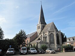
Steenhuffel church
|
|||
|
|||
| Location in Belgium | |||
| Coordinates: 51°00′N 04°18′E / 51.000°N 4.300°ECoordinates: 51°00′N 04°18′E / 51.000°N 4.300°E | |||
| Country | Belgium | ||
| Community | Flemish Community | ||
| Region | Flemish Region | ||
| Province | Flemish Brabant | ||
| Arrondissement | Halle-Vilvoorde | ||
| Government | |||
| • Mayor | Jozef De Borger (CD&V) | ||
| • Governing party/ies | CD&V | ||
| Area | |||
| • Total | 36.29 km2 (14.01 sq mi) | ||
| Population (1 January 2016) | |||
| • Total | 18,274 | ||
| • Density | 500/km2 (1,300/sq mi) | ||
| Postal codes | 1840 | ||
| Area codes | 052, 015 | ||
| Website | www.londerzeel.be | ||
Londerzeel (Dutch pronunciation: [ˈlɔndərzeːl]) is a municipality located in the Belgian province of Flemish Brabant. The municipality comprises the towns of Londerzeel proper, Malderen, Steenhuffel (home of Palm Breweries) and Sint-Jozef. On 1 January 2006, Londerzeel had a total population of 17,435. The total area is 36.29 km² which gives a population density of 480 inhabitants per km².
Their football team is K. Londerzeel S.K..
Londerzeel has been twinned with Gladenbach (Germany) since 2010.
...
Wikipedia


