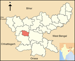
Lohardaga district
|
Lohardaga district लोहरदग्गा जिला |
|
|---|---|
| District of Jharkhand | |
 Location of Lohardaga district in Jharkhand |
|
| Country | India |
| State | Jharkhand |
| Administrative division | South Chotanagpur division |
| Headquarters | Lohardaga |
| Government | |
| • Lok Sabha constituencies | Lohardaga (shared with Gumla district) |
| • Assembly seats | 1 |
| Area | |
| • Total | 1,490.80 km2 (575.60 sq mi) |
| Population (2011) | |
| • Total | 461,738 |
| • Density | 310/km2 (800/sq mi) |
| Demographics | |
| • Literacy | 68.29% |
| • Sex ratio | 985 |
| Website | Official website |
Lohardaga district (Hindi: लोहरदग्गा जिला) is one of the twenty-four districts of the Indian state of Jharkhand. The district is named after the town of Lohardaga, the administrative headquarters of the district. The district was created from a portion of Ranchi district in 1983.
The district is situated between 23°30' and 23°40' north latitudes and 84°40' and 84°50' east longitudes. The district covers an area of 1491 km².
As of 2011, it is the least populous district of Jharkhand (out of 24).
It is currently a part of the Red Corridor.
The inhabitants of this district mainly depend on agriculture, forest produce and seasonal migration to different parts of the country. 80% of the population depends upon agriculture. The main crop of this area is paddy. In the small irrigated area wheat is grown to meet the annual food sufficiency. Also this district is linked with larger vegetable markets like Jamshedpur, Rourkela and Calcutta. There is a cold storage in the district. But profitable vegetable cultivation is being limited to road side non-tribals. Generally, villagers of the district keep plough animals. Also they keep goats and poultry birds as buffer. Although there is a dairy chilling plant in the district headquarters, dairy is practised by very few people mainly non-tribal.
The net sown area is only 55% of the total area of the district. Two blocks i.e. Kisko and Senha have large area under dense forest cover. The forest cover is around 32-35% of the total area of the district. The average land holding per household is 1.65 Ha. The per capita agriculture land is around 0.28 Ha. Net irrigated area is 13.4% of net sown area (0.8% by canals, 7% by wells, 2% by tanks & 3.6% by lift irrigation and others).
Most of the villages except the hilly pockets of the district are connected with the roads. Still some of the hamlets have no linking roads. Electricity is supplied from Patratu Thermal Power Station which is in the Hazaribagh district. Out of 354 villages only 25 have rural electrification. Water supply system is not available in rural area. The villagers get their drinking water from tube wells and dug wells.
...
Wikipedia
