Lockbourne, Ohio
| Lockbourne, Ohio | |
|---|---|
| Village | |

Namesake site in Lock Meadows Park
|
|
 Location of Lockbourne, Ohio |
|
 Location of Lockbourne in Franklin County |
|
| Coordinates: 39°48′32″N 82°58′14″W / 39.80889°N 82.97056°WCoordinates: 39°48′32″N 82°58′14″W / 39.80889°N 82.97056°W | |
| Country | United States |
| State | Ohio |
| County | Franklin, Pickaway County |
| Area | |
| • Total | 0.80 sq mi (2.07 km2) |
| • Land | 0.75 sq mi (1.94 km2) |
| • Water | 0.05 sq mi (0.13 km2) |
| Elevation | 712 ft (217 m) |
| Population (2010) | |
| • Total | 237 |
| • Estimate (2012) | 241 |
| • Density | 316.0/sq mi (122.0/km2) |
| Time zone | Eastern (EST) (UTC-5) |
| • Summer (DST) | EDT (UTC-4) |
| ZIP code | 43137 |
| Area code(s) | 614 |
| FIPS code | 39-44310 |
| GNIS feature ID | 1065015 |
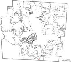
Lockbourne is a village in Franklin County and Pickaway County, Ohio, United States. The population was 237 at the 2010 census. Lockbourne is located near Rickenbacker International Airport, and had initially provided its original name of Lockbourne Air Force Base.
Lockbourne was laid out in the early 1830s. It takes its name from the locks of the Ohio and Erie Canal, on which it was situated.
Lockbourne is located at 39°48′32″N 82°58′14″W / 39.80889°N 82.97056°W (39.809008, -82.970528).
According to the United States Census Bureau, the village has a total area of 0.80 square miles (2.07 km2), of which, 0.75 square miles (1.94 km2) is land and 0.05 square miles (0.13 km2) is water.
As of the census of 2010, there were 237 people, 95 households, and 69 families residing in the village. The population density was 316.0 inhabitants per square mile (122.0/km2). There were 108 housing units at an average density of 144.0 per square mile (55.6/km2). The racial makeup of the village was 97.9% White, 0.4% from other races, and 1.7% from two or more races. Hispanic or Latino of any race were 2.5% of the population.
...
Wikipedia
