Lochbuie, Colorado
| Town of Lochbuie, Colorado | |
|---|---|
| Statutory Town | |

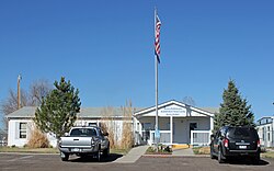
The Lochbuie Administration Building.
|
|
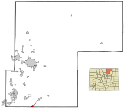
 Location in Weld County and the state of Colorado |
|
| Coordinates: 40°0′36″N 104°42′29″W / 40.01000°N 104.70806°WCoordinates: 40°0′36″N 104°42′29″W / 40.01000°N 104.70806°W | |
| Country |
|
| State |
|
| Counties |
Weld County Adams County |
| Incorporated | May 1974 |
| Government | |
| • Type | Statutory Town |
| Area | |
| • Total | 1.3 sq mi (3.6 km2) |
| • Land | 1.3 sq mi (3.5 km2) |
| • Water | 0 sq mi (0.1 km2) |
| Elevation | 5,020 ft (1,530 m) |
| Population (2010) | |
| • Total | 4,726 |
| • Density | 3,635.4/sq mi (1,350.3/km2) |
| Time zone | MST (UTC-7) |
| • Summer (DST) | MDT (UTC-6) |
| ZIP code | 80603 |
| Area code(s) | Both 303 and 720 |
| FIPS code | 08-45530 |
| GNIS feature ID | 1669461 |
| Website | Town of Lochbuie |
The Town of Lochbuie is a Statutory Town located in Weld and Adams counties in the U.S. state of Colorado. The town population was 4726 at the 2010 United States Census.
Lochbuie is located at 40°0′36″N 104°42′29″W / 40.01000°N 104.70806°W (40.009864, -104.708080).
According to the United States Census Bureau, the town has a total area of 1.4 square miles (3.5 km²), of which, 1.3 square miles (3.5 km²) of it is land and 0.04 square miles (0.1 km²) of it (1.47%) is water.
Lochbuie was developed in the 1960s as the Spacious Living Mobile Home Park, and known as Space City until it was incorporated in 1974. The town was named Lochbuie after Lochbuie, Mull in Scotland.
As of the census of 2000, there were 2,049 people, 1,643 households, and 518 families residing in the town. The population density was 1,531.6 people per square mile (590.4/km²). There were 654 housing units at an average density of 488.9 per square mile (188.4/km²). The racial makeup of the town was 73.94% White, 0.24% African American, 0.63% Native American, 0.15% Asian, 22.69% from other races, and 2.34% from two or more races. Hispanic or Latino of any race were 35.92% of the population.
...
Wikipedia
