Loch Raven Boulevard
| Maryland Route 542 | ||||
|---|---|---|---|---|

Maryland Route 542 highlighted in red
|
||||
| Route information | ||||
| Maintained by MDSHA and Baltimore DOT | ||||
| Length: | 6.33 mi (10.19 km) | |||
| Existed: | 1935 – present | |||
| Major junctions | ||||
| South end: |
|
|||
| North end: |
|
|||
| Location | ||||
| Counties: | City of Baltimore, Baltimore | |||
| Highway system | ||||
|
||||
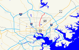
Maryland Route 542 (MD 542) is a state highway in the U.S. state of Maryland. Known for most of its length as Loch Raven Boulevard, the state highway runs 6.33 miles (10.19 km) from MD 147 in Baltimore north to Interstate 695 (I-695) and Cromwell Bridge Road near Towson. MD 542 is a four-lane divided highway that connects portions of Northeast Baltimore with Towson and I-695. The state highway is maintained by the Maryland State Highway Administration in Baltimore County and the Baltimore City Department of Transportation in the city. MD 542 was constructed in the early to mid-1930s. The highway was expanded to a divided highway in Baltimore by 1950 and in Baltimore County in the mid- to late 1950s.
MD 542 begins at an intersection with MD 147 (Harford Road) adjacent to Clifton Park in Baltimore. St. Lo Drive heads south into the city park on the south side of the intersection. The state highway heads north as The Alameda, a four-lane divided boulevard through the Coldstream-Homestead-Montebello neighborhood, where the highway passes Baltimore City College. North of 33rd Street, MD 542 heads through the Ednor Gardens-Lakeside neighborhood north to Loch Raven Boulevard. MD 542 switches to Loch Raven Boulevard while The Alameda continues through the Northwood neighborhood. The state highway intersects Cold Spring Lane and crosses Chinquapin Run. North of Good Samaritan Hospital, MD 542 intersects Northern Parkway and leaves the city limits.
...
Wikipedia

