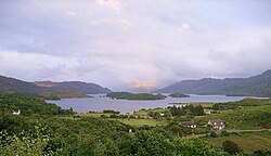
Loch Morar
| Loch Morar | |
|---|---|

The shallower western end of the loch
|
|
| Location | Lochaber, Highland |
| Coordinates | 56°57′00″N 5°40′20″W / 56.95000°N 5.67222°WCoordinates: 56°57′00″N 5°40′20″W / 56.95000°N 5.67222°W |
| Type | freshwater loch, dimictic, oligotrophic |
| Primary inflows | River Meoble |
| Primary outflows | River Morar |
| Catchment area | 168 square kilometres (65 sq mi) |
| Basin countries | Scotland |
| Max. length | 18.8 km (11.7 mi) |
| Surface area | 26.7 km2 (10.3 sq mi) |
| Average depth | 87 metres (284 ft) |
| Max. depth | 310 m (1,017 ft) |
| Water volume | 2.3073 cubic kilometres (81,482,000,000 cu ft) |
| Surface elevation | 9 metres (30 ft) |
Loch Morar (Scottish Gaelic: Loch Mhòrair) is a freshwater loch in Lochaber, Highland, Scotland. It is the fifth-largest loch by surface area in Scotland, at 26.7 km2 (10.3 sq mi), and the deepest freshwater body in the British Isles with a maximum depth of 310 m (1,017 ft). The loch was created by glacial action around 10,000 years ago, and has a surface elevation of 9 metres (30 ft) above sea level.
Loch Morar is 18.8 kilometres (11.7 mi) long, has a surface area of 26.7 km2 (10.3 sq mi), and is the deepest freshwater body in the British Isles with a maximum depth of 310 m (1,017 ft). In 1910, John Murray and Laurence Pullar found it to have a mean depth of 87 metres (284 ft) and a total volume of 2.3073 cubic kilometres (81,482,000,000 cu ft) during their survey of Scottish lochs. The bottom is deepened below the United Kingdom Continental Shelf, and until 1943, when a depth of 324 metres (1,062 ft) was observed in the Inner Sound, it was believed to be the deepest water in the United Kingdom. The surface of the loch is 9 metres (30 ft) above sea level.
The water of the loch is clear and oligotrophic, with a minimal intake of nutrients, making it a Site of Special Scientific Interest (SSSI). The main inflow is the River Meoble at the southern end, which drains from Loch Beoraid, although there are three other major inflows at the eastern end of the loch and a stream draining a complex of lochans to the north-west of Loch Morar. The outflow is the River Morar at the western end, which at a few hundred metres long is one of the shortest rivers in the British Isles. At the shallower western end of the loch, there are a number of sizeable forested islands.
Swordland Lodge, on the northern shore of the loch, was used as training school STS 23b during the Second World War by the Special Operations Executive. A 750 KW hydroelectric power station with a hydraulic head of 5.5 metres (18 ft) was built on the River Morar in 1948.
...
Wikipedia

