Lloydminster, Saskatchewan
| Lloydminster | |||
|---|---|---|---|
| City | |||
| City of Lloydminster | |||

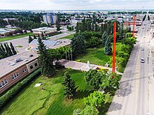
An aerial view of Lloydminster City Hall looking north along the Alberta / Saskatchewan border
|
|||
|
|||
| Nickname(s): "Border City" or "Canada's Border City", "Heavy Oil Capital of Canada" | |||
 Location of Lloydminster in Alberta and Saskatchewan |
|||
| Coordinates: 53°16.7′N 110°0.3′W / 53.2783°N 110.0050°WCoordinates: 53°16.7′N 110°0.3′W / 53.2783°N 110.0050°W | |||
| Country | Canada | ||
| Provinces |
Alberta (AB) Saskatchewan (SK) |
||
| Regions |
Central Alberta, West Central Saskatchewan |
||
| Census divisions | 10 (AB), 17 (SK) | ||
| Incorporated | |||
| • Village (SK) | November 25, 1903 | ||
| • Village (AB) | July 6, 1906 | ||
| • Town (SK) | April 1, 1907 | ||
| • Amalgamation | May 22, 1930 | ||
| • City | January 1, 1958 | ||
| Government | |||
| • Mayor | Gerald Aalbers | ||
| • Governing body |
Lloydminster City Council
|
||
| • City Manager | Glenn Carroll | ||
| • MP |
Shannon Stubbs (AB, CPC) Gerry Ritz (SK, CPC) |
||
| • MLA |
Richard Starke (AB, PC) Colleen Young (SK, SP) |
||
| Area (2011) | |||
| • City | 41.53 km2 (16.03 sq mi) | ||
| Elevation | 645 m (2,116 ft) | ||
| Population (2011) | |||
| • City | 27,804 – 18,032 (AB) – 9,772 (SK) |
||
| • Density | 669.5/km2 (1,734/sq mi) | ||
| • Urban | 27,804 | ||
| • Municipal census (2015) | 31,377 – 19,740 (AB) – 11,637 (SK) |
||
| Time zone | MST (UTC−7) | ||
| • Summer (DST) | MDT (UTC−6) | ||
| Postal code span | T9V (AB), S9V (SK) | ||
| Area code(s) | 306, 587, 639, 780 | ||
| Website | Official website | ||
Lloydminster is a Canadian city which has the unusual geographic distinction of straddling the provincial border between Alberta and Saskatchewan. Unlike most such cases (such as Texarkana and Kansas City), Lloydminster is not a pair of twin cities on opposite sides of a border which merely share the same name, but is actually incorporated by both provinces as a single city with a single municipal administration.
Intended to be an exclusively British Utopian settlement centred on the idea of sobriety, the town was founded in 1903 by the Barr Colonists, who came directly from the United Kingdom. At a time when the area was still part of the North-West Territories, the town was located astride the Fourth Meridian of the Dominion Land Survey. This meridian was intended to coincide with 110° west longitude, although the imperfect surveying methods of the time led to the surveyed meridian being placed a few hundred meters west of this longitude.
The town was named for George Lloyd (Anglican Bishop of Saskatchewan), a strong opponent of non-British immigration to Canada. During a nearly disastrous immigration journey, which was badly planned and conducted, he distinguished himself with the colonists and replaced the Barr Colony's leader and namesake Isaac Montgomery Barr during the colonists' journey to the eventual townsite.
...
Wikipedia


