Livermore, Maine
| Livermore, Maine | |
|---|---|
| Town | |
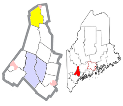
 Location of Livermore (in yellow) in Androscoggin County and the state of Maine |
|
| Location in the United States | |
| Coordinates: 44°24′31″N 70°13′28″W / 44.40861°N 70.22444°W | |
| Country | United States |
| State | Maine |
| County | Androscoggin |
| Area | |
| • Total | 39.40 sq mi (102.05 km2) |
| • Land | 37.62 sq mi (97.44 km2) |
| • Water | 1.78 sq mi (4.61 km2) |
| Elevation | 650 ft (198 m) |
| Population (2010) | |
| • Total | 2,095 |
| • Estimate (2012) | 2,092 |
| • Density | 55.7/sq mi (21.5/km2) |
| Time zone | Eastern (EST) (UTC-5) |
| • Summer (DST) | EDT (UTC-4) |
| ZIP code | 04253 |
| Area code(s) | 207 |
| FIPS code | 23-40665 |
| GNIS feature ID | 0582566 |
Livermore is a town in Androscoggin County, Maine, United States. Formerly in Oxford County, Maine. The population was 2,095 at the 2010 United States Census. It is included in both the Lewiston-Auburn, Maine Metropolitan Statistical Area and the Lewiston-Auburn, Maine Metropolitan New England City and Town Area. High schools students from Livermore attend Spruce Mountain High School in neighboring Livermore Falls. Livermore is known for The Norlands, the Washburn family home.
Livermore was incorporated in 1795, the north- western town of the Androscoggin County. In 1880, the population was 1,262. In 2010, the population was 2,095. Livermore had originally been a grant from the state of Massachusetts to certain people for services in an expedition, which was against Port Royal. The town was named for Deacon Elijah Livermore, a pioneer settler born in Waltham, Mass. The first two settlers of Livermore are known to be Deacon Ellijah Livermore and Major Thomas Fish. Major Thomas Fish had originally been from Worcester County, Oxford, Massachusetts. Major Thomas Fish went to war in 1775, and he was a Major in the Continental Army. Major Thomas Fish had died on December 20, 1781 in Livermore, Maine. Deacon Ellijah Livermore had arrived in 1779, building the first mill near Long Pond in 1782. In 1795 as Livermore familiarized, a county line was established based on the Androscoggin River. The Androscoggin River divides East Livermore and Leeds on the east and south- east. On the south of the river is Turner, on the west side is Canton and Hartford, and on the north side is Jay and Canton. From 1760 to 1805, Livermore had been in Cumberland and Lincoln Counties. In 1805, the town became part of Oxford County. By the act of East Livermore, Livermore was separated from Oxford County and became part of the Kennebunk County. On March 1, 1844, the town of East Livermore had been incorporated in the Kennebec County, but soon had set off to created the Androscoggin County. The county line had determined the east of the river as the Kennebec County, and the west part of the Oxford County. On March 31, 1854, the towns of Turner and Livermore officially set off from Oxford County to the Androscoggin County.
...
Wikipedia

