Littlebredy
| Littlebredy | |
|---|---|
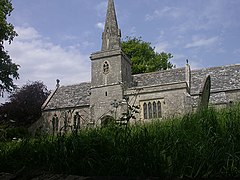
 Parish church of St Michael and All Angels |
|
| Littlebredy shown within Dorset | |
| Population | 121 |
| OS grid reference | SY588890 |
| District | |
| Shire county | |
| Region | |
| Country | England |
| Sovereign state | United Kingdom |
| Police | Dorset |
| Fire | Dorset and Wiltshire |
| Ambulance | South Western |
| EU Parliament | South West England |
| UK Parliament |
|
| Website | Village website |
Littlebredy (also written Little Bredy, pronounced "Briddy") is a small village and civil parish in the English county of Dorset, situated in the West Dorset administrative district approximately 6.5 miles (10.5 km) west of the county town Dorchester. It is sited at the head of the valley of the small River Bride, surrounded by wooded chalk hills of the Dorset Downs. The parish contains the Valley of Stones National Nature Reserve and is in an area rich with evidence of early human occupation. In the 2011 census it had a population of 121.
The area around Littlebredy is rich with evidence of early human occupation, including stone circles, strip lynchets, tumuli (long and round barrows) and a probable hill fort. North and east of the village the density of barrows is as great as the area around Stonehenge. One mile north of the village and just outside the parish is a group of 44 Bronze Age round barrows of various sizes, known as Winterbourne Poor Lot Barrows or just Poor Lot. On a hill immediately south of the village are the earthworks of Old Warren (or Danes' Camp), which most likely was a univallate (single rampart) Iron Age hill fort. Old Warren may later have been used as a burh in the time of Alfred the Great, though it may have been not completed, or abandoned in favour of a site at what is now Bridport.
...
Wikipedia

