Little Scoat Fell
| Scoat Fell | |
|---|---|
 |
|
| Highest point | |
| Elevation | 841 m (2,759 ft) |
| Prominence | c. 46 m |
| Parent peak | Pillar |
| Listing | Nuttall, Hewitt, Wainwright |
| Coordinates | 54°29′24″N 3°17′59″W / 54.49004°N 3.2998°WCoordinates: 54°29′24″N 3°17′59″W / 54.49004°N 3.2998°W |
| Geography | |
| Location | Cumbria, England |
| Parent range | Lake District, Western Fells |
| OS grid | NY159113 |
| Topo map | OS Landranger 89, Explorer OL4 |
| Listed summits of Scoat Fell | ||||
| Name | Grid ref | Height | Status | |
|---|---|---|---|---|
| Black Crag | NY165116 | 828 m (2,716 ft) | Hewitt | |
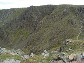
Scoat Fell is a fell in the western part of the English Lake District. It stands at the head of the Mosedale Horseshoe with its back to Ennerdale. Paths lead to Scoat Fell from Ennerdale over Steeple, from Wasdale over Red Pike, and along the ridge from Pillar.
The Western Fells occupy a triangular sector of the Lake District, bordered by the River Cocker to the north east and Wasdale to the south east. Westwards the hills diminish toward the coastal plain of Cumberland. At the central hub of the high country are Great Gable and its satellites, while two principal ridges fan out on either flank of Ennerdale, the western fells in effect being a great horseshoe around this long wild valley. Scoat Fell is on the southern arm.
The main watershed runs broadly westwards from Great Gable, dividing the headwaters of Ennerdale and Wasdale. The principal fells in this section are Kirk Fell, Pillar, Scoat Fell, Haycock and Caw Fell, followed by the lower Lank Rigg group.
Scoat Fell occupies an important position at the crossroads of five ridges. To the east, across the subsidiary top of Black Crag, is Pillar. Southward is a long descending ridge heading toward the shore of Wastwater. The high point is Red Pike, before the terminal height of Yewbarrow. The main watershed continues west to Haycock, while two short spurs jut north into Ennerdale. These are Tewit How which descends from the western end of the plateau and Steeple, running from the summit.
...
Wikipedia

