Little River (Greater Geelong)
| Little (Diabagnorite, Worrin-yaloke) | |
| River | |
|
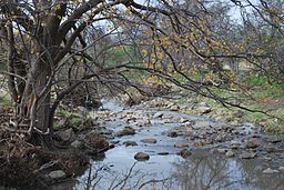
Little River, near its source in Staughton Vale
|
|
| Country | Australia |
|---|---|
| State | Victoria |
| Regions | Victorian Midlands (IBRA), Greater Metropolitan Melbourne |
| LGA | City of Greater Geelong, City of Wyndham |
| Part of | Port Phillip & Westernport catchment |
| Tributaries | |
| - left | Balliang Creek |
| - right | Stony Creek (Greater Geelong), Reilly Creek |
| Town | Little River |
| Source | Brisbane Ranges |
| - location | Staughton Vale |
| - elevation | 176 m (577 ft) |
| - coordinates | 37°49′35″S 144°16′57″E / 37.82639°S 144.28250°E |
| Mouth | Port Phillip |
| - location | north of Beacon Point |
| - elevation | 0 m (0 ft) |
| - coordinates | 38°0′20″S 144°45′42″E / 38.00556°S 144.76167°ECoordinates: 38°0′20″S 144°45′42″E / 38.00556°S 144.76167°E |
| Length | 49 km (30 mi) |
The Little River is a perennial stream of the Port Phillip & Westernport catchment, located in the Greater Metropolitan Melbourne region of the Australian state of Victoria.
The Little River rises in the Brisbane Ranges, near Staughton Vale and flows generally east, joined by three minor tributaries, before reaching its mouth at Port Phillip, north of Beacon Point near the boundary between the City of Greater Geelong and the City of Wyndham. The river descends 176 metres (577 ft) over its 49 kilometres (30 mi) course.
The traditional Aboriginal name of the river is Diabagnorite or Worrin-yaloke.
...
Wikipedia


