Linwood, New Jersey
| Linwood, New Jersey | |
|---|---|
| City | |
| City of Linwood | |

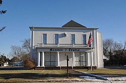
Masonic Temple
|
|
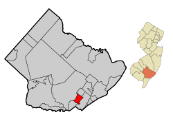
 Map of Linwood in Atlantic County. Inset: Location of Atlantic County highlighted in the State of New Jersey. |
|
 Census Bureau map of Linwood, New Jersey |
|
| Coordinates: 39°20′37″N 74°34′16″W / 39.343718°N 74.57105°WCoordinates: 39°20′37″N 74°34′16″W / 39.343718°N 74.57105°W | |
| Country |
|
| State |
|
| County | Atlantic |
| Incorporated | February 20, 1889 (as borough) |
| Reincorporated | April 27, 1931 (as city) |
| Government | |
| • Type | City |
| • Body | City Council |
| • Mayor | Richard E. DePamphilis, III (term ends December 31, 2019) |
| • Clerk | Leigh Ann Napoli |
| Area | |
| • Total | 4.242 sq mi (10.987 km2) |
| • Land | 3.865 sq mi (10.010 km2) |
| • Water | 0.377 sq mi (0.977 km2) 8.89% |
| Area rank | 290th of 566 in state 19th of 23 in county |
| Elevation | 30 ft (9 m) |
| Population (2010 Census) | |
| • Total | 7,092 |
| • Estimate (2015) | 6,973 |
| • Rank | 317th of 566 in state 13th of 23 in county |
| • Density | 1,834.9/sq mi (708.5/km2) |
| • Density rank | 302nd of 566 in state 8th of 23 in county |
| Time zone | Eastern (EST) (UTC-5) |
| • Summer (DST) | Eastern (EDT) (UTC-4) |
| ZIP code | 08221 |
| Area code(s) | 609 |
| FIPS code | 3400140530 |
| GNIS feature ID | 0885280 |
| Website | www |
Linwood is a city in Atlantic County, New Jersey, United States. As of the 2010 United States Census, the city's population was 7,092, reflecting a decline of 80 (-1.1%) from the 7,172 counted in the 2000 Census, which had in turn increased by 306 (+4.5%) from the 6,866 counted in the 1990 Census.
Linwood was originally incorporated as a borough by an act of the New Jersey Legislature on February 20, 1889, from portions of Egg Harbor Township, based on the results of a referendum held the previous day. Linwood was reincorporated as a city on April 27, 1931. The area had been called Leedsville until 1880, when a post office was being established. The United States Postal Service insisted that the name had to be changed as it conflicted with an existing post office elsewhere in the state. Among the names proposed and considered by local residents were "Brinola", "Geneva", "Pearville" and "Viola", with "Linwood" ultimately chosen.
The community encompassing the area traces its existence to colonial times.
According to the United States Census Bureau, the city had a total area of 4.242 square miles (10.987 km2), including 3.865 square miles (10.010 km2) of land and 0.377 square miles (0.977 km2) of water (8.89%).
The city is located about 9 miles (14 km) west of Atlantic City. It borders the municipalities of Northfield, Egg Harbor Township and Somers Point. Linwood is known for its large, expensive homes, particularly in communities such as The Gold Coast, Fischer Woods, and Fischer Greene.
...
Wikipedia
