Lingenfeld
| Lingenfeld | ||
|---|---|---|
|
||
| Coordinates: 49°14′43″N 8°20′40″E / 49.24537°N 8.34442°ECoordinates: 49°14′43″N 8°20′40″E / 49.24537°N 8.34442°E | ||
| Country | Germany | |
| State | Rhineland-Palatinate | |
| District | Germersheim | |
| Municipal assoc. | Lingenfeld | |
| Government | ||
| • Mayor | Hans Jürgen Wallat (CDU) | |
| Area | ||
| • Total | 15.33 km2 (5.92 sq mi) | |
| Elevation | 104 m (341 ft) | |
| Population (2015-12-31) | ||
| • Total | 5,728 | |
| • Density | 370/km2 (970/sq mi) | |
| Time zone | CET/CEST (UTC+1/+2) | |
| Postal codes | 67360 | |
| Dialling codes | 06344 | |
| Vehicle registration | GER | |
| Website | www.lingenfeld.de | |
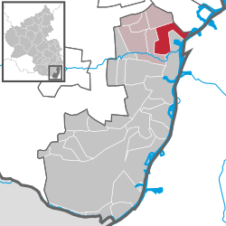
Lingenfeld is a municipality in the district of Germersheim, in Rhineland-Palatinate, Germany. It is situated approximately 5 km north-west of Germersheim, and 10 km south-west of Speyer.
Lingenfeld has about 5900 citizens and is continuously growing because of its excellent connections to nearby cities such as Speyer, Mannheim, Ludwigshafen and Karlsruhe via the S-Bahn ("suburban railway").
Lingenfeld is the seat of the Verbandsgemeinde ("collective municipality") Lingenfeld.
Lingenfeld is located in the Upper Rhine valley in the south of the German wine-growing region Palatinate ("Pfalz") in Rhineland-Palatinate. Close by are the river Rhine in the East of the village and the German Wine Route to the West. Neighbouring places are Römerberg (Pfalz) to the north, Schwegenheim and Westheim (Pfalz) to the west, Germersheim to the south and the frontier to Baden-Württemberg realised through the cut-off meander of the Rhine to the east.
In past centuries the old current of the Rhine caused the loss of about 250 hectares of land due to undermining of the banks.
Lingenfeld lies 104 meters higher than the other communities close to the Rhine, so danger of flooding can be almost entirely excluded.
...
Wikipedia


