Linden, California
| Linden | |
|---|---|
| Census-designated place | |
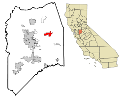
 Location in San Joaquin County and the state of California |
|
| Location in the United States | |
| Coordinates: 38°1′12″N 121°5′29″W / 38.02000°N 121.09139°WCoordinates: 38°1′12″N 121°5′29″W / 38.02000°N 121.09139°W | |
| Country |
|
| State |
|
| County | San Joaquin |
| Government | |
| • State senator | Cathleen Galgiani (D) |
| • Assemblymember | Heath Flora (R) |
| • U. S. rep. | Jerry McNerney (D) |
| Area | |
| • Total | 7.461 sq mi (19.324 km2) |
| • Land | 7.409 sq mi (19.189 km2) |
| • Water | 0.052 sq mi (0.135 km2) 0.70% |
| Elevation | 92 ft (28 m) |
| Population (2010) | |
| • Total | 1,784 |
| • Density | 240/sq mi (92/km2) |
| Time zone | Pacific Time Zone (UTC-8) |
| • Summer (DST) | PDT (UTC-7) |
| ZIP code | 95236 |
| Area code | 209 |
| FIPS code | 06-41670 |
| GNIS feature ID | 277540 |
Linden is a census-designated place (CDP) in San Joaquin County, California, United States. The population was 1,784 at the 2010 census, up from 1,103 at the 2000 census. Host of the Linden Cherry Festival each summer.
Linden is located at 38°1′12″N 121°5′29″W / 38.02000°N 121.09139°W (38.019989, -121.091450).
According to the United States Census Bureau, the CDP has a total area of 7.5 square miles (19 km2), 99.30% of it land and 0.70% of it water.
Located along California Highway 26.
The 2010 United States Census reported that Linden had a population of 1,784. The population density was 239.1 people per square mile (92.3/km²). The racial makeup of Linden was 1,541 (86.4%) White, 6 (0.3%) African American, 10 (0.6%) Native American, 25 (1.4%) Asian, 1 (0.1%) Pacific Islander, 127 (7.1%) from other races, and 74 (4.1%) from two or more races. Hispanic or Latino of any race were 385 persons (21.6%).
...
Wikipedia

