Lincolnville, Maine
| Lincolnville, Maine | |
|---|---|
| Town | |

Centennial celebration in 1902
|
|
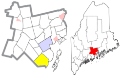
 Location of Lincolnville (in yellow) in Waldo County and the state of Maine |
|
| Coordinates: 44°17′41″N 69°4′47″W / 44.29472°N 69.07972°W | |
| Country | United States |
| State | Maine |
| County | Waldo |
| Incorporated | 1802 |
| Area | |
| • Total | 43.65 sq mi (113.05 km2) |
| • Land | 37.34 sq mi (96.71 km2) |
| • Water | 6.31 sq mi (16.34 km2) |
| Elevation | 230 ft (70 m) |
| Population (2010) | |
| • Total | 2,164 |
| • Estimate (2012) | 2,170 |
| • Density | 58.0/sq mi (22.4/km2) |
| Time zone | Eastern (EST) (UTC-5) |
| • Summer (DST) | EDT (UTC-4) |
| ZIP code | 04849 |
| Area code(s) | 207 |
| FIPS code | 23-39755 |
| GNIS feature ID | 0582561 |
| Website | town.lincolnville.me.us |
Lincolnville is a town in Waldo County, Maine, United States. The population was 2,164 at the 2010 census. Lincolnville is the mainland terminal for state ferry service to Islesboro.
Approximately 10,000 years ago, a glacier covered the area to a depth of several thousand feet, carving irregular landforms that survive today. The earliest artifact of European origin was fragments of a 1650-1660 clay pipe, probably a trade good with the native population. First settled in 1774, the town was incorporated in 1802 from Canaan and Ducktrap plantations. It was named for General Benjamin Lincoln, a Revolutionary War General and friend of Henry Knox.
The first school in Lincolnville was a three-sided log cabin with a perpendicular ledge for a fourth wall behind Nathan Knight's home; the ledge served to support a blackboard.
Over the years, the population continued to grow until it was incorporated in 1802. A bicentennial celebration was celebrated by the town in 2002.
According to the United States Census Bureau, the town has a total area of 43.65 square miles (113.05 km2), of which, 37.34 square miles (96.71 km2) is land and 6.31 square miles (16.34 km2) is water. Located along the western side of Penobscot Bay, Lincolnville is drained by the Ducktrap River. Priciple bodies of water include: Megunticook Lake, Norton Pond (123 acres), Coleman Pond (225 acres), Moody Pond (61 acres) and Levenseller Pond (34 acres).
The town is served by U.S. Route 1, Maine State Routes 173, 52 and 235. It is bordered by Belmont on the north, Northport on the northeast, Penobscot Bay on the east, Camden on the south, Hope on the west and Searsmont on the northwest.
...
Wikipedia
