Lincoln County, NC
| Lincoln County, North Carolina | |
|---|---|

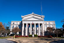
Lincoln County Courthouse in Lincolnton
|
|
 Location in the U.S. state of North Carolina |
|
 North Carolina's location in the U.S. |
|
| Founded | 1779 |
| Named for | Benjamin Lincoln |
| Seat | Lincolnton |
| Largest city | Lincolnton |
| Area | |
| • Total | 307 sq mi (795 km2) |
| • Land | 298 sq mi (772 km2) |
| • Water | 9.1 sq mi (24 km2), 3.0% |
| Population | |
| • (2010) | 78,265 |
| • Density | 263/sq mi (102/km²) |
| Congressional district | 10th |
| Time zone | Eastern: UTC-5/-4 |
| Website | www |
Lincoln County is a county located in the U.S. state of North Carolina. As of the 2010 census, the population was 78,265. Its county seat is Lincolnton. Lincoln County is included in the Charlotte-Concord-Gastonia, NC-SC Metropolitan Statistical Area.
The county was formed in 1779 from the eastern part of Tryon County, which had been settled by Europeans in the mid-18th Century. It was named for Benjamin Lincoln, a general in the American Revolutionary War." During the American Revolution, the Battle of Ramsour's Mill occurred near a grist mill in Lincolnton.
"In 1782 the southeastern part of Burke County was annexed to Lincoln County. In 1841 parts of Lincoln County and Rutherford County were combined to form Cleveland County. In 1842 the northern third of Lincoln County became Catawba County. In 1846 the southern half of what was left of Lincoln County became Gaston County."
According to the U.S. Census Bureau, the county has a total area of 307 square miles (800 km2), of which 298 square miles (770 km2) is land and 9.1 square miles (24 km2) (3.0%) is water.
...
Wikipedia
