Lincoln County, Kentucky
| Lincoln County, Kentucky | |
|---|---|

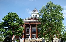
Lincoln County courthouse in Stanford
|
|
 Location in the U.S. state of Kentucky |
|
 Kentucky's location in the U.S. |
|
| Founded | 1780 |
| Named for | Benjamin Lincoln |
| Seat | Stanford |
| Largest city | Stanford |
| Area | |
| • Total | 337 sq mi (873 km2) |
| • Land | 334 sq mi (865 km2) |
| • Water | 2.5 sq mi (6 km2), 0.7% |
| Population | |
| • (2010) | 24,742 |
| • Density | 74/sq mi (29/km²) |
| Congressional district | 5th |
| Time zone | Eastern: UTC-5/-4 |
| Website | www |
Lincoln County is a county located in the U.S. state of Kentucky. As of the 2010 census, the population was 24,742. Its county seat is Stanford. Lincoln is a prohibition or "dry county."
Lincoln County is part of the Danville, KY Micropolitan Statistical Area.
Organized in 1780, Lincoln County was not named for the later president (b. 1809), but for the American Revolutionary War general Benjamin Lincoln.
Lincoln was one of the original three counties formed out of Virginia's Kentucky County. (The other two were Fayette and Jefferson counties.) These three were separated from Virginia to create the Commonwealth of Kentucky in 1792.
The county's original seat was at Harrodsburg, but that part of Lincoln County became Mercer County in 1785.
According to the U.S. Census Bureau, the county has a total area of 337 square miles (870 km2), of which 334 square miles (870 km2) is land and 2.5 square miles (6.5 km2) (0.7%) is water.
Lincoln County is located in South Central Kentucky in the southern part of the ring of Knobs around the Bluegrass region. It includes the headwaters of the Green River.
...
Wikipedia
