Lime Springs
| Lime Springs, Iowa | |
|---|---|
| City | |
 |
|
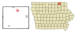
 Location of Lime Springs, Iowa |
|
| Coordinates: 43°26′58″N 92°16′52″W / 43.44944°N 92.28111°WCoordinates: 43°26′58″N 92°16′52″W / 43.44944°N 92.28111°W | |
| Country | United States |
| State | Iowa |
| County | Howard |
| Area | |
| • Total | 1.02 sq mi (2.64 km2) |
| • Land | 1.02 sq mi (2.64 km2) |
| • Water | 0 sq mi (0 km2) |
| Elevation | 1,240 ft (378 m) |
| Population (2010) | |
| • Total | 505 |
| • Estimate (2016) | 485 |
| • Density | 495/sq mi (191.2/km2) |
| Time zone | Central (CST) (UTC-6) |
| • Summer (DST) | CDT (UTC-5) |
| ZIP code | 52155 |
| Area code(s) | 563 |
| FIPS code | 19-45165 |
| GNIS feature ID | 0458350 |
Lime Springs is a city in Howard County, Iowa, United States. The population was 505 at the 2010 census.
The Old Town of Lime Spring was platted in 1857. After the railroad was built into the area, the town relocated nearby to its tracks. The town, then called Lime Spring Station, was platted again in 1867.
Lime Springs is located at 43°26′58″N 92°16′52″W / 43.44944°N 92.28111°W (43.449578, -92.281226).
The town center originally existed a little farther to the north around the Lidtke Mill on the Upper Iowa River, but moved south when the railroad came to town.
According to the United States Census Bureau, the city has a total area of 1.02 square miles (2.64 km2), all of it land.
As of the census of 2010, there were 505 people, 238 households, and 143 families residing in the city. The population density was 495.1 inhabitants per square mile (191.2/km2). There were 253 housing units at an average density of 248.0 per square mile (95.8/km2). The racial makeup of the city was 99.4% White, 0.2% Native American, and 0.4% Asian. Hispanic or Latino of any race were 0.4% of the population.
...
Wikipedia
