Lika-Krbava
| Lika-Krbava County Ličko-krbavska županija Lika-Korbava vármegye |
|||||
| County of the Kingdom of Croatia-Slavonia | |||||
|
|||||
|
Coat of arms |
|||||
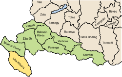
| Location of the County (yellow) within the Kingdom of Croatia-Slavonia (green) | |||||
| Capital |
Gospić 44°33′N 15°22′E / 44.550°N 15.367°ECoordinates: 44°33′N 15°22′E / 44.550°N 15.367°E |
||||
| History | |||||
| • | Established | 15 July 1881 | |||
| • | Treaty of Trianon | 4 June 1920 | |||
| Area | |||||
| • | 1910 | 6,211 km2(2,398 sq mi) | |||
| Population | |||||
| • | 1910 | 204,710 | |||
| Density | 33 /km2 (85.4 /sq mi) | ||||
| Today part of | Croatia | ||||
Coat of arms
Lika-Krbava County (Croatian: Ličko-krbavska županija; Serbian: Личко-крбавска жупанија; Hungarian: Lika-Korbava vármegye) was a historic administrative subdivision (županija) of the Kingdom of Croatia-Slavonia. Croatia-Slavonia was an autonomous kingdom within the Lands of the Crown of Saint Stephen (Transleithania), the Hungarian part of the dual Austro-Hungarian Empire. Its territory is now in southwestern Croatia. Lika and Krbava are the names of two valleys in the county (Gospić lies in Lika). The capital of the county was Gospić (Croatian, in Hungarian: Goszpics).
Lika-Krbava county shared borders with the Austrian Kingdom of Dalmatia and Bosnia-Herzegovina and the county of Modruš-Rijeka (also in Croatia-Slavonia). The county has a strip of Adriatic Sea coast. Its area was 6211 km² around 1910.
...
Wikipedia


