Lighthouse, Chennai

Chennai Lighthouse
|
|
|
India Tamil Nadu
|
|
| Location | Kamarajar Salai, Marina Beach, Santhome, Chennai |
|---|---|
| Coordinates | 13°02′23″N 80°16′46″E / 13.039802°N 80.279575°ECoordinates: 13°02′23″N 80°16′46″E / 13.039802°N 80.279575°E |
| Year first constructed | 1796 (first) 1844 (second) 1894 (third) |
| Year first lit | 1977 (current) built by East Coast Constructions |
| Foundation | reinforced concrete (Current location) |
| Construction | reinforced concrete |
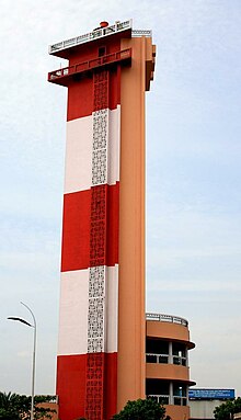
| Tower shape | triangular prism with lantern and double gallery |
| Markings / pattern | red and white horizontal bands |
| Height | 45.72 metres (150.0 ft) |
| Focal height | 57 metres (187 ft) above MSL |
| Original lens | 375 mm 3rd order revolving optic inside 2.5 m dia lantern house (BBT) |
| Intensity | 110V 3000W Incandescent Lamp |
| Range | 28 nautical miles (52 km; 32 mi) |
| Characteristic | Fl (2) W10s. |
| Admiralty number | F 0936 |
| NGA number | 27072 |
| ARLHS number | IND-010 |
The Madras Light House (Tamil: சென்னைக் கலங்கரை விளக்கம்) is a lighthouse facing the Bay of Bengal on the east coast of the Indian Subcontinent. It is a famous landmark on the Marina Beach in Chennai, India. It was built by the East Coast Constructions and Industries in 1976 replacing the old lighthouse in the northern direction. The lighthouse was opened in January 1977. It also houses the meteorological department and was restricted to visitors. On 16 November 2013, it was reopened to visitors. It is one of the few lighthouses in the world with an elevator. It is also the only lighthouse in India within the city limits.
The lighthouse is located on Kamarajar Salai (Beach Road) opposite the office of the Director General of Tamil Nadu Police and All India Radio's Chennai station. The lighthouse marks the end of the promenade on the northern half of the Marina Beach. It is also the junction where Kamarajar Salai, Santhome High Road and Dr.Radhakrishnan Salai meet. The lighthouse and the surrounding areas are served by the Light House MRTS station located nearby on Dr.Radhakrishnan Salai 13°02′42″N 80°16′36″E / 13.0450°N 80.2768°E.
By the end of the 18th century, the Madras Presidency encompassed much of south India and also Ceylon. As its capital, the city of Madras served as the nerve centre of the sea trade controlled by the British East India Company. Ships approaching the shore of Madras after nightfall faced the risk of running aground on the shoals of Covelong (Kovalam) in the south and the sand-banks of Armagon and Pulicat in the north.
...
Wikipedia

