Liberty City
| Liberty City | |
|---|---|
| Neighborhood of Miami | |

Liberty City mural
|
|
| Nickname(s): Model City (historic name) | |
 The Liberty City neighborhood in Miami |
|
| Country |
|
| State |
|
| County | Miami-Dade County |
| City | Miami |
| Government | |
| • City of Miami Commissioner | Keon Hardemon |
| • Miami-Dade Commissioners | Audrey Edmonson |
| • House of Representatives | Cynthia Stafford (D) and Roy Hardemon (D) |
| • State Senate | Larcenia Bullard (D) and Oscar Braynon (D) |
| • U.S. House | Frederica Wilson (D) |
| Elevation | 3 m (10 ft) |
| Population (2010) | |
| • Total | 19,725 |
| • Density | 3,733/km2 (9,669/sq mi) |
| Time zone | EST (UTC-05) |
| ZIP Code | 33125, 33127, 33142, 33147, 33150 |
| Area code(s) | 305, 786 |
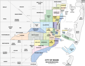
Liberty City is a neighborhood in Miami, Florida, United States. The area is roughly bound by NW 79th Street to the north, NW 27th Avenue to the west, Northwest 36th Street to the South, and Interstate 95 to the east. The Miami neighborhood is home to one of the largest concentrations of African Americans in South Florida, as of 2000[update] Census. Although often referred to as "Model City" both historically and by the City of Miami government, the neighborhood is more commonly referred to as "Liberty City" by local residents.
It is serviced by the Miami Metrorail at Dr. Martin Luther King Jr. Plaza and Brownsville stations along NW 27th Avenue.
Once a part of the sparsely populated outskirts of northern Miami, what became Liberty City developed during the Great Depression of the 1930s when President Franklin D. Roosevelt authorized the construction of the Liberty Square housing project in 1933, the first of its kind in the Southern United States. Built as a response to the deteriorating housing conditions in densely populated and covenant-restricted slums of Overtown, construction on the initial housing project began in 1934 and opened in 1937.
...
Wikipedia
