Lianga, Surigao del Sur
| Lianga | |
|---|---|
| Municipality | |

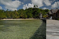
Kansilad Beach Resort in Lianga
|
|
 Map of Surigao del Sur with Lianga highlighted |
|
| Location within the Philippines | |
| Coordinates: 08°38′N 126°06′E / 8.633°N 126.100°ECoordinates: 08°38′N 126°06′E / 8.633°N 126.100°E | |
| Country | Philippines |
| Region | Caraga (Region XIII) |
| Province | Surigao del Sur |
| District | 1st district of Surigao del Sur |
| Founded | October 17, 1919 |
| Barangays | 13 |
| Government | |
| • Mayor | Kid Pedrozo |
| Area | |
| • Total | 161.12 km2 (62.21 sq mi) |
| Population (2015 census) | |
| • Total | 29,493 |
| • Density | 180/km2 (470/sq mi) |
| Time zone | PST (UTC+8) |
| ZIP code | 8307 |
| IDD : area code | +63 (0)86 |
| Income class | 4th municipal income class |
| 166811000 | |
| Electorate | 19,787 voters as of 2016 |
| Website | www |
Lianga is a fourth class municipality in the province of Surigao del Sur, Philippines. According to the 2015 census, it has a population of 29,493 people.
About a couple of centuries ago, along the bountiful bay facing the bluish sea of the Pacific Ocean was a place like those in fairy tales. the white beaches were traversed by two rivers, one in the south and the other in the north. A little distance from the shoreline, the landscape started to the rise until it reached its peak at the west which is one of the ranges of the enchanted Mount Diwata. The place was thickly forested, blanketed with big trees, varieties of wild flowers aerial plants and vines. On the ground, wild animals of different species roam around the area. White colorful birds and other winged creatures flit from tree to tree. Nature's Music like chirping of birds, humming of bees and other wood land insects intermingling with the sound of roaring waves could be heard from the distance. This truly translates the feeling of being born free with nature. the place was breathtaking to behold. Indeed, it was Paradise where nature remained undisturbed.
Then men settled along the cove near river in the south. It was said that these early inhabitants were the Manobos who were ruled by a Chieftain (Datu). Their clothes were made of woven abaca fiber and adorned themselves with multi-colored beads. Land and water resources were abundant, hence they love to hunt in the forest, gather shells along the shores and fish in the rivers. there was peace and harmony among the early inhabitants. They were happy and contended. Later however, as their tribes increased their descendants thought of moving to surrounding areas, so there was rivalry as to who will own choice pieces of land. Whenever disputes overland ownership and quarrel among themselves occurred, it was settled in a duel alongside the river in the North. Whoever won was proclaimed a "Daugan" o "Mananaog" by the Chieftain (Datu). The place became popular, hence the river was named Pananag-an.
People going to the other side of the river have to wade across it slowly as the current was swift, it always took them such time to reach the other side of the river and they often say to themselves "Langan Pagtabok" of "Malangan Kita" (It delays to cross or we will be delayed). One day, as the old folks claimed, a foreigner passed by the place. After having crossed the river, he asked the people the name of the place. Thinking that the stranger was asking what they were doing, they answered "Langan pagtabok". The foreigner heard "Langan" and thought it was the name of the place, then people started calling the whole settlement "Langan". Later, with he influence of the Spanish "Li" alphabet, Langan was pronounced "Liangan". As generations passed, the final "N" in Llangan was dropped and the "Ll" sound was changed to "Li", hence says that is how Lianga got its name.
...
Wikipedia

