Leudelange
|
Leudelange Leideleng |
||
|---|---|---|
| Commune | ||

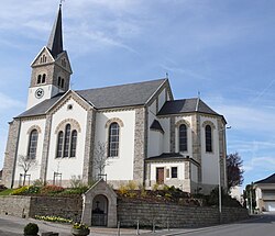
The church of Leudelange
|
||
|
||
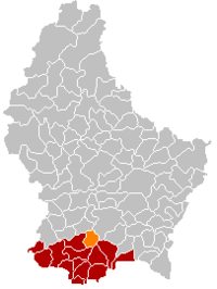
 Map of Luxembourg with Leudelange highlighted in orange, and the canton in dark red |
||
| Coordinates: 49°34′00″N 6°04′00″E / 49.5667°N 6.0667°ECoordinates: 49°34′00″N 6°04′00″E / 49.5667°N 6.0667°E | ||
| Country |
|
|
| Canton | Esch-sur-Alzette | |
| Government | ||
| • Mayor | Diane Bisenius-Feipel | |
| Area | ||
| • Total | 13.57 km2 (5.24 sq mi) | |
| Area rank | 87 of 105 | |
| Highest elevation | 359 m (1,178 ft) | |
| • Rank | 80th of 105 | |
| Lowest elevation | 276 m (906 ft) | |
| • Rank | 80th of 105 | |
| Population (2014) | ||
| • Total | 2,305 | |
| • Rank | 59th of 105 | |
| • Density | 170/km2 (440/sq mi) | |
| • Density rank | 44th of 105 | |
| Time zone | CET (UTC+1) | |
| • Summer (DST) | CEST (UTC+2) | |
| LAU 2 | LU00010007 | |
| Website | leudelange.lu | |
Leudelange (Luxembourgish: Leideleng, German: Leudelingen) is a commune and town in south-western Luxembourg. It is situated in the canton of Esch-sur-Alzette, district of Luxembourg.
As of 2007[update], the town of Leudelange, which lies in the centre of the commune, had a population of 2,100.
Leudelange was formed on 1 July 1856, when it was detached from the commune of Reckange-sur-Mess. The law forming Leudelange was passed on the 3 March 1856.
Gilles Müller, professional tennis player
...
Wikipedia

