Leudal
|
Leudal Leudaal |
|||
|---|---|---|---|
| Municipality | |||

Water mill Friedesse in Neer
|
|||
|
|||
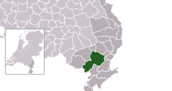
 Location in Limburg |
|||
| Coordinates: 51°15′N 5°54′E / 51.250°N 5.900°ECoordinates: 51°15′N 5°54′E / 51.250°N 5.900°E | |||
| Country | Netherlands | ||
| Province | Limburg | ||
| Established | 1 January 2007 | ||
| Government | |||
| • Body | Municipal council | ||
| • Mayor | Arno Verhoeven (PvdA) | ||
| Area | |||
| • Total | 164.89 km2 (63.66 sq mi) | ||
| • Land | 162.78 km2 (62.85 sq mi) | ||
| • Water | 2.11 km2 (0.81 sq mi) | ||
| Elevation | 28 m (92 ft) | ||
| Population (February 2017) | |||
| • Total | 36,232 | ||
| • Density | 223/km2 (580/sq mi) | ||
| Time zone | CET (UTC+1) | ||
| • Summer (DST) | CEST (UTC+2) | ||
| Postcode | Parts of 6000 range | ||
| Area code | 0475, 0495 | ||
| Website | www |
||
Leudal (Limburgish: Leudaal) is a municipality in the Dutch province of Limburg. It was formed on January 1, 2007 in a merger of the municipalities of Heythuysen, Haelen, Hunsel, and Roggel en Neer.
The municipality contains the following population centres:
Dutch Topographic map of the municipality of Leudal, June 2015
...
Wikipedia


