Letterkenny Township, Franklin County, Pennsylvania
| Letterkenny Township, Franklin County, Pennsylvania |
|
|---|---|
| Township | |

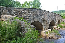
Pre-Civil War Horse Valley Bridge
|
|
 Map of Franklin County, Pennsylvania highlighting Letterkenny Township |
|
 Map of Franklin County, Pennsylvania |
|
| Country | United States |
| State | Pennsylvania |
| County | Franklin |
| Settled | 1736 |
| Incorporated | 1761 |
| Area | |
| • Total | 70.5 sq mi (182.6 km2) |
| • Land | 70.4 sq mi (182.3 km2) |
| • Water | 0.1 sq mi (0.3 km2) |
| Population (2010) | |
| • Total | 2,318 |
| • Density | 33/sq mi (12.7/km2) |
| Time zone | Eastern (EST) (UTC-5) |
| • Summer (DST) | EDT (UTC-4) |
| Area code(s) | 717 |
| Website | letterkennytownship |
Letterkenny Township is a township in Franklin County, Pennsylvania, United States. The population was 2,318 at the 2010 census, up from 2,074 at the 2000 census.
The township is named after Letterkenny in County Donegal, Ireland. The Horse Valley Bridge, Rocky Spring Presbyterian Church, and Skinner Tavern are listed on the National Register of Historic Places.
The township is in north-central Franklin County. The eastern half of the township is in the Great Appalachian Valley, while the western half occupied by the eastern two ridges of the Ridge-and-Valley Appalachians. Broad Mountain and Blue Mountain form the easternmost ridge, while Kittatinny Mountain forms the western town border. Between the two ridges is Horse Valley, drained northeastward by Conodoguinet Creek, which turns and forms the northern boundary of the township as the creek leaves the mountains and enters the Great Appalachian Valley.
The southeastern part of the township is within the Letterkenny Army Depot. North of the depot are the unincorporated communities of Upper Strasburg and Pleasant Hall.
According to the United States Census Bureau, the township has a total area of 70.5 square miles (182.6 km2), of which 70.4 square miles (182.3 km2) is land and 0.12 square miles (0.3 km2), or 0.19%, is water.
...
Wikipedia
