Les Abymes, Guadeloupe
| Les Abymes | |
|---|---|

The Main Square in Les Abymes
|
|
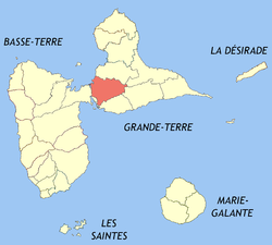
 Location of the commune (in red) within Guadeloupe |
|
| Coordinates: 16°16′N 61°31′W / 16.27°N 61.52°WCoordinates: 16°16′N 61°31′W / 16.27°N 61.52°W | |
| Country | France |
| Overseas region and department | Guadeloupe |
| Arrondissement | Pointe-à-Pitre |
| Canton | Les Abymes 1 through 5 |
| Intercommunality | Cap Excellence |
| Government | |
| • Mayor (2008-2020) | Éric Jalton |
| Area1 | 81.25 km2 (31.37 sq mi) |
| Population (2013)2 | 58,644 |
| • Density | 720/km2 (1,900/sq mi) |
| INSEE/Postal code | 97101 / 97139 and 97142 |
| Elevation | 0–120 m (0–394 ft) |
|
1 French Land Register data, which excludes lakes, ponds, glaciers > 1 km² (0.386 sq mi or 247 acres) and river estuaries. 2Population without double counting: residents of multiple communes (e.g., students and military personnel) only counted once. |
|
1 French Land Register data, which excludes lakes, ponds, glaciers > 1 km² (0.386 sq mi or 247 acres) and river estuaries.
Les Abymes (French pronunciation: [lɛz‿a.bim]) is the most populated commune in the French overseas region and department of Guadeloupe, in the Lesser Antilles. It is located on the west side of the island of Grande-Terre, and is part of the metropolitan area of Pointe-à-Pitre, the largest urban area in Guadeloupe.
The inhabitants of the commune are known as Abymiens or Abymiennes.
Les Abymes is located some 3 km north-east of Pointe-à-Pitre, 7 km east of Baie Mahault, and 10 km south-west of Morne-à-l'Eau. Access to the commune is by Route nationale N1 from Baie-Mahault in the west which passes along the southern border of the commune and continues south as the N4. The N5 branches off the N1 and goes north-east through the centre of the commune and continues north-east to Morne-a-L'eau. The N11 branches off the N5 on the south-east of the town and continues north-west then west rejoining the N1. The D106 road also goes north from the commune to Vieux Bourg. The Route du Palais Royal passes north-east through the commune to join the N5. The Route de Chazeau branches from the Route du Palais Royal and goes north-east to Doubs.
Access to the Pointe-à-Pitre International Airport is from the N11.
Les Abymes is integrated into the urban area of Pointe-à-Pitre and, like the rest of the island, has a tropical climate.
The islands have been occupied since pre-Columbian times. Some remains have been found in the Dothémare area but the most remarkable were those found in Belle Plaine where surveys conducted by the Direction régionale des affaires culturelles (DRAC) in 2006 revealed the existence of a sizeable town dated from 1000 and 1200 AD (Troumassoid culture).
...
Wikipedia
