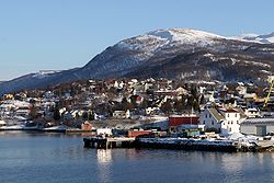
Lenvik
|
Lenvik kommune Leaŋgáviika suohkan |
|||
|---|---|---|---|
| Municipality | |||
 |
|||
|
|||
 Lenvik within Troms |
|||
| Coordinates: 69°23′1″N 17°58′3″E / 69.38361°N 17.96750°ECoordinates: 69°23′1″N 17°58′3″E / 69.38361°N 17.96750°E | |||
| Country | Norway | ||
| County | Troms | ||
| District | Midt-Troms | ||
| Administrative centre | Finnsnes | ||
| Government | |||
| • Mayor (2011) | Geir-Inge Sivertsen (H) | ||
| Area | |||
| • Total | 892.38 km2 (344.55 sq mi) | ||
| • Land | 848.74 km2 (327.70 sq mi) | ||
| • Water | 43.64 km2 (16.85 sq mi) | ||
| Area rank | 125 in Norway | ||
| Population (2012) | |||
| • Total | 11,345 | ||
| • Rank | 93 in Norway | ||
| • Density | 13.4/km2 (35/sq mi) | ||
| • Change (10 years) | 2.4 % | ||
| Demonym(s) | Lenvikværing | ||
| Time zone | CET (UTC+1) | ||
| • Summer (DST) | CEST (UTC+2) | ||
| ISO 3166 code | NO-1931 | ||
| Official language form | Neutral | ||
| Website | www |
||
|
|
|||
Lenvik (Northern Sami: Leaŋgáviika) is a municipality in Troms county, Norway. The municipality is partly situated on the mainland, partly on the island of Senja. The administrative centre is the town of Finnsnes, where the Gisund Bridge connects Senja to the mainland on Norwegian County Road 86. Other villages in the municipality include Aglapsvik, Gibostad, Botnhamn, Fjordgård, Finnfjordbotn, Husøy, Langnes, Laukhella, Silsand, and Rossfjordstraumen. The lake Lysvatnet is located on Senja island west of Gibostad.
The large municipality of Lenvik was established on 1 January 1838 (see formannskapsdistrikt). In 1848, most of the mainland parts of Lenvik (population: 2,616) was separated to form the new municipality of Målselv, leaving Lenvik with 3,029 residents. Then in 1855, the northern part of Lenvik (population: 811) was separated to form the new municipality of Hillesøy. This left Lenvik with 2,757 inhabitants. On 1 January 1871, a small part of Lenvik (population: 70) was transferred to the neighboring municipality of Malangen.
...
Wikipedia


