Lens, Switzerland
| Lens | ||
|---|---|---|

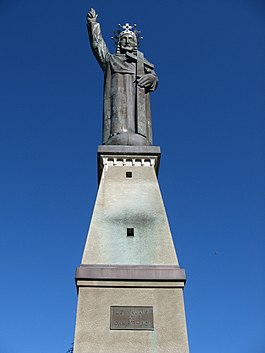
Statue du Christ Roi above Lens village
|
||
|
||
| Coordinates: 46°16′N 7°26′E / 46.267°N 7.433°ECoordinates: 46°16′N 7°26′E / 46.267°N 7.433°E | ||
| Country | Switzerland | |
| Canton | Valais | |
| District | Sierre | |
| Government | ||
| • Mayor | David Bagnoud | |
| Area | ||
| • Total | 13.91 km2 (5.37 sq mi) | |
| Elevation | 1,129 m (3,704 ft) | |
| Population (Dec 2015) | ||
| • Total | 3,986 | |
| • Density | 290/km2 (740/sq mi) | |
| Demonym(s) | Les Lensards | |
| Postal code | 1978 | |
| SFOS number | 6240 | |
| Localities | Crans-sur-Sierre, Flanthey, Chelin | |
| Surrounded by | Saint-Léonard, Icogne, Randogne, Montana, Chermignon, Sierre | |
| Website |
www SFSO statistics |
|
Lens is a municipality in the district of Sierre in the canton of Valais in Switzerland.
Lens is first mentioned in 1177 as de Lenz.
Lens has an area, as of 2009[update], of 13.9 square kilometers (5.4 sq mi). Of this area, 5.07 km2 (1.96 sq mi) or 36.4% is used for agricultural purposes, while 5.48 km2 (2.12 sq mi) or 39.4% is forested. Of the rest of the land, 2.74 km2 (1.06 sq mi) or 19.7% is settled (buildings or roads), 0.1 km2 (25 acres) or 0.7% is either rivers or lakes and 0.46 km2 (0.18 sq mi) or 3.3% is unproductive land.
Of the built up area, housing and buildings made up 11.2% and transportation infrastructure made up 4.0%. while parks, green belts and sports fields made up 3.8%. Out of the forested land, 33.6% of the total land area is heavily forested and 5.8% is covered with orchards or small clusters of trees. Of the agricultural land, 0.4% is used for growing crops and 11.6% is pastures, while 9.1% is used for orchards or vine crops and 15.3% is used for alpine pastures. All the water in the municipality is in lakes.
The municipality is located in the Sierre district, on the right bank of the Rhone. It consists of the villages of Lens, Chelin, Flanthey, Vaas, Saint-Clément and Valençon as well as a portion of the resort of Crans-Montana.
It is perched on the saddle of a hill that projects out into the valley. The adjacent hilltop features a bronze statue of Christ, some 28 meters (92 ft) in height. The statue, and the ornate chapel in its base, can be visited on foot by following a path up through the surrounding woods. The path is marked by a series of shrines depicting the Stations of the Cross. The platform at the top commands a spectacular view up and down the Rhone valley, from Martigny (to the west), as far as Leuk (to the east).
The blazon of the municipal coat of arms is Azure four Mullets of Five Or between two Keys of the same in Saltire.
...
Wikipedia


