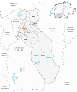
Chermignon
| Chermignon | ||
|---|---|---|
| Former municipality of Switzerland | ||
|
||
| Coordinates: 46°19′N 7°28′E / 46.317°N 7.467°ECoordinates: 46°19′N 7°28′E / 46.317°N 7.467°E | ||
| Country | Switzerland | |
| Canton | Valais | |
| District | Sierre | |
| Government | ||
| • Mayor | Jean-Claude Savoy | |
| Area | ||
| • Total | 5.4 km2 (2.1 sq mi) | |
| Elevation | 910 m (2,990 ft) | |
| Population (December 2002) | ||
| • Total | 2,772 | |
| • Density | 510/km2 (1,300/sq mi) | |
| Postal code | 3971 Chermignon 3963 Crans-sur-Sierre 3971 Ollon |
|
| SFOS number | 6234 | |
| Surrounded by | Lens, Montana, Sierre | |
| Website |
www SFSO statistics |
|
Chermignon is a former municipality in the district of Sierre in the canton of Valais in Switzerland. On 1 January 2017 the former municipalities of Chermignon, Mollens, Montana and Randogne merged into the new municipality of Crans-Montana.
Chermignon is first mentioned in 1228 as Chermenon and Chirminon. It became an independent municipality in 1905 when it separated from Lens.
Chermignon had an area, as of 2009[update], of 5.4 square kilometers (2.1 sq mi). Of this area, 2.09 km2 (0.81 sq mi) or 38.8% is used for agricultural purposes, while 1.64 km2 (0.63 sq mi) or 30.5% is forested. Of the rest of the land, 1.54 km2 (0.59 sq mi) or 28.6% is settled (buildings or roads), 0.02 km2 (4.9 acres) or 0.4% is either rivers or lakes and 0.07 km2 (17 acres) or 1.3% is unproductive land.
Of the built up area, industrial buildings made up 1.3% of the total area while housing and buildings made up 17.3% and transportation infrastructure made up 6.1%. while parks, green belts and sports fields made up 3.3%. Out of the forested land, 22.5% of the total land area is heavily forested and 8.0% is covered with orchards or small clusters of trees. Of the agricultural land, 0.2% is used for growing crops and 22.9% is pastures, while 15.8% is used for orchards or vine crops. Of the water in the municipality, 0.2% is in lakes and 0.2% is in rivers and streams.
The former municipality is located in the Sierre district, on the right side of the Rhone river. It consists of the villages of Chermignon d'en Haut (1,168 m [3,832 ft]) and Chermignon d'en Bas (927 m [3,041 ft]) on a terrace, the hamlets of Champzabé (595 m [1,952 ft]) and Ollon at the bottom of the slope and a portion of the resort of Crans-sur-Sierre (1,460 m [4,790 ft]).
...
Wikipedia


