Lempa river
| Lempa River | |
|
Sunset over the Lempa river
|
|
| Countries | El Salvador, Honduras, Guatemala |
|---|---|
| Source | Sierra Madre |
| - location | Olopa, Chiquimula, Guatemala |
| - elevation | 1,200 m (3,937 ft) |
| - coordinates | 14°41′33″N 89°18′18″W / 14.69250°N 89.30500°W |
| Mouth | Pacific Ocean |
| - location | El Playón, Tecoluca, San Vicente, El Salvador |
| - elevation | 0 m (0 ft) |
| - coordinates | 13°15′17″N 88°49′38″W / 13.25472°N 88.82722°WCoordinates: 13°15′17″N 88°49′38″W / 13.25472°N 88.82722°W |
| Length | 422 km (262 mi) |
| Basin | 18,246 km2 (7,045 sq mi) |
| Discharge | for Cuscatlan bridge |
| - average | 362 m3/s (12,784 cu ft/s) |
|
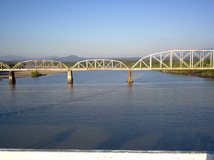
Railroad Bridge (FENADESAL) over the Lempa river, as seen from the Carretera del Litoral highway bridge (El Salvador)
|
|
The Lempa River (Spanish: Río Lempa) is a 422-kilometre (262 mi) long river in Central America.
Its sources are located in between the Sierra Madre and the Sierra del Merendón in southern Guatemala, near the town of Olopa. In Guatemala the river is called Río Olopa and flows southwards for 30.4 kilometres (18.9 mi) before entering Honduras and changing its name to Lempa river at 14°32′52″N 89°15′50″W / 14.547700°N 89.264002°W. In Honduras it flows through Ocotepeque Department for 31.4 kilometres (19.5 mi), and crosses the border with El Salvador at the town of Citalá (14°22′19″N 89°12′45″W / 14.371857°N 89.212439°W) in the department of Chalatenango. The river continues its course for another 360 kilometres (220 mi) in El Salvador, flowing in a generally southwards direction until it reaches the Pacific Ocean in the department of San Vicente. The river forms a small part of the international boundary between El Salvador and Honduras.
...
Wikipedia


