Lem Ferreira
| Lem Ferreira | |
|---|---|
| Neighborhood | |

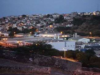
Early morning view of Lem Ferreira from the Plateau with bits of Achada Grande and the SCCR beverage factory
|
|
| Country | Cape Verde |
| Island | Santiago Island |
| City | Praia |
| Postal code | 7600 |
| Website | www.cmpraia.cv |
Lem Ferreira (older spelling Lém Ferreira) is a subdivision in the east of Praia in the island of Santiago, Cape Verde just east of the Plateau which is the city center. The size is very small, its length is 560 meters and its width ranges from 100 meters in the south to 360 meters in the middle. Its approximate size is about 20 to 25 hectares.
Bordering neighborhoods include Covão Mendes to the northeast, Achada Grande Frente to the east and the south, the Plateau or the City Center to the west and Paiol to the north. One of the boundaries is west of Ribeira da Trindade in the west, Avenida Combatentes da Liberdade da Patria and Caminho de Covão Mendes where Ribeira da Água Funda is located, the boundary curves around the tributary area along with Ribeira de Safende.
The lowest point is Ribeira da Trindade at 7 meters, the middle is at about 30 meters, 12 meters in the northwest, 14 meters in the north, 40 meters in the northeast at Rua do Aeroporto and the highest is 50 meters which is in the east.
Lem Ferreira covers the slopy area between Ribeira da Trindade and Achada Grande de Santiago. Ribeira da Trindade is in the westernmost part with its mouth outside the neighborhood boundaries, much of the tributary with Ribeiras da Água Funda and de Safende is included.
The main streets and roads include Rua do Aeroporto linking the airport along with Praia and the middle and the north of the island and Avenida Charles Darwin (then Rua do Porto), named after the naturalist who visited Praia in 1832, it connects with the Port of Praia.
One part of Lem Ferreira features colorful houses, some parts features houses with unpainted walls.
Before the urban sprawl reached the southernmost point of the island in the 1960s, the area was predominantly barren and rarely forested.
Agriculture dominated the northern part to the 1970s when the urban sprawl of Praia spread to the area. The entire area became urbanized by the early 1980s. Some houses were built recently in the early 2010s. The north and the south slope portions at the extreme areas remains to be forested.
In 2001, construction of a Rua da Aeroporto began which ran north of Lem Ferreira and was completed in 2004. Between mid 2015 and early 2016, Avenida Charles Darwin was repaved and added a sidewalk on the left side.
...
Wikipedia
