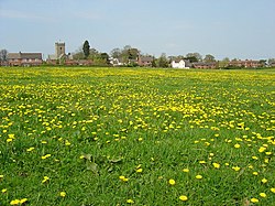
Leigh, Staffordshire
| Leigh | |
|---|---|
 The village of Church Leigh |
|
| Leigh shown within Staffordshire | |
| Population | 906 |
| OS grid reference | SK020350 |
| • London | 148 mi (238 km) |
| Civil parish |
|
| District | |
| Shire county | |
| Region | |
| Country | England |
| Sovereign state | United Kingdom |
| Post town | STOKE-ON-TRENT |
| Postcode district | ST10 |
| Dialling code | 01889 |
| Police | Staffordshire |
| Fire | Staffordshire |
| Ambulance | West Midlands |
| EU Parliament | West Midlands |
| UK Parliament | |
Leigh is a civil parish in the English county of English county of Staffordshire. The parish includes the village of Church Leigh, together with the settlements of Withington, Upper Leigh, Lower Leigh, Morrilow Heath, Middleton Green, Dods Leigh, Godstone and Field.
Church Leigh is 6.2 miles (10.0 km) WNW of the town of Uttoxeter, 14.3 miles (23.0 km) north east of Stafford and 148 miles (238 km) north west of London. The other settlements are within 3 miles (4.8 km) of Church Leigh.
Church Leigh lies 0.8 miles south of the A50 that runs from Warrington to Leicester and is dualled on this section (between Stoke-on-Trent and the M1 motorway).
The nearest railway station is at Uttoxeter for the Crewe to Derby line on the national network.
The nearest airport is East Midlands Airport between Derby, Loughborough and Nottingham.
Church Leigh has an entry in the Domesday Book of 1085. In the great book Church Leigh is recorded by the name Lege
The civil parish of Leigh is centred on the clustered village of Church Leigh but has six satellite hamlets. Separating the last four from the first is a field buffer including the River Blithe which flows south, via the Blithfield Reservoir lake 5 miles (8.0 km) south to feed the River Trent at Alrewas, Staffordshire.
...
Wikipedia

