Lea Valley Walk
| Lea Valley Walk | |
|---|---|

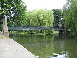
The trail goes through Wardown Park
|
|
| Length | 50 mi (80 km) |
| Location | South East England |
| Trailheads |
Leagrave Limehouse Basin |
| Use | Hiking, Cycling, Angling, Boating |
| Hiking details | |
| Season | All year |
The Lea Valley Walk is a 50-mile (80 km) long-distance path located between Leagrave, the source of the River Lea near Luton, and the Thames, at Limehouse Basin, Limehouse, east London. From its source much of the walk is rural. At Hertford the path follows the towpath of the River Lee Navigation, and it becomes increasingly urbanised as it approaches London. The walk was opened in 1993 and is waymarked throughout using a swan logo.
Approximately 19.9 miles (32.0 km)
The walk can be accessed close to Leagrave railway station at Leagrave Common where there are a number of springs and ponds from which the Lea forms. The first part of the walk is through the suburbs of Luton. After passing through Wardown Park the path joins the A6 road and goes through the town centre passing St Mary's Church as it heads close to the runways of Luton Airport. The A505 road is crossed as the trail makes its way through open countryside towards Harpenden.
The path descends into the Lea Valley, passing under the railway lines before crossing the B653 road. The route now follows the track of a disused railway, the former Luton, Dunstable and Welwyn Junction line. After Harpenden the path leaves the railway track and heads uphill into Wheathampstead, then it goes through the village, past the church, and crosses over to the other bank of the river. The path now follows the river towards Water End Lane and the grounds of Brocket Hall where it crosses the middle of a golf course on its way towards Lemsford. The path goes under the A1 road to Stanborough Park.
...
Wikipedia
