LeRoy, Kansas
| LeRoy, Kansas | |
|---|---|
| City | |
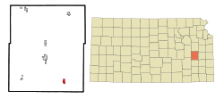
 Location within Coffey County and Kansas |
|
 KDOT map of Coffey County (legend) |
|
| Coordinates: 38°5′2″N 95°37′59″W / 38.08389°N 95.63306°WCoordinates: 38°5′2″N 95°37′59″W / 38.08389°N 95.63306°W | |
| Country | United States |
| State | Kansas |
| County | Coffey |
| Area | |
| • Total | 0.83 sq mi (2.15 km2) |
| • Land | 0.82 sq mi (2.12 km2) |
| • Water | 0.01 sq mi (0.03 km2) |
| Elevation | 1,004 ft (306 m) |
| Population (2010) | |
| • Total | 561 |
| • Estimate (2015) | 548 |
| • Density | 680/sq mi (260/km2) |
| Time zone | Central (CST) (UTC-6) |
| • Summer (DST) | CDT (UTC-5) |
| ZIP code | 66857 |
| Area code | 620 |
| FIPS code | 20-39650 |
| GNIS feature ID | 0478086 |
| Website | leroykansas.com |
LeRoy is a city in Coffey County, Kansas, United States. As of the 2010 census, the city population was 561.
LeRoy was founded in 1855. It was named after the city of Le Roy, Illinois.
The first post office in LeRoy (a name also spelled historically as Leroy) was established in 1856.
During the Civil War the town had a military post from 1861 to 1864. LeRoy's post was one of a number of posts in eastern Kansas that existed to guard against Confederate guerrilla attacks and attacks by unfriendly Indians. On May 22, 1862, the 1st Regiment, Indian Home Guard was organized at Le Roy.
LeRoy is located at 38°5′2″N 95°37′59″W / 38.08389°N 95.63306°W (38.083958, -95.633139). According to the United States Census Bureau, the city has a total area of 0.83 square miles (2.15 km2), of which 0.82 square miles (2.12 km2) is land and 0.01 square miles (0.03 km2) is water.
The climate in this area is characterized by hot, humid summers and generally mild to cool winters. According to the Köppen Climate Classification system, LeRoy has a humid subtropical climate, abbreviated "Cfa" on climate maps.
As of the census of 2010, there were 561 people, 230 households, and 156 families residing in the city. The population density was 684.1 inhabitants per square mile (264.1/km2). There were 269 housing units at an average density of 328.0 per square mile (126.6/km2). The racial makeup of the city was 97.9% White, 0.2% Native American, 0.2% Asian, and 1.8% from two or more races. Hispanic or Latino of any race were 1.6% of the population.
...
Wikipedia
