Lavras
| Lavras | |||
|---|---|---|---|
| Municipality | |||

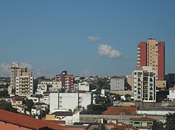
Partial view of the central region
|
|||
|
|||
| Etymology: Mining and tillage | |||
| Nickname(s): Cidade dos Ipês e das Escolas ("City of the Ipês and Schools") | |||
| Anthem: Hino do município de Lavras | |||
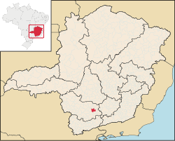
 Location of Lavras |
|||
| Coordinates: 21°14′42″S 45°00′00″W / 21.24500°S 45.00000°WCoordinates: 21°14′42″S 45°00′00″W / 21.24500°S 45.00000°W | |||
| Country |
|
||
| Region | Southeast | ||
| State |
|
||
| Mesoregion | Campo das Vertentes | ||
| Founded | 1729 | ||
| Town rights | 1831 | ||
| Government | |||
| • Mayor | José Cherem (PSD) | ||
| Area | |||
| • Total | 564.495 km2 (217.953 sq mi) | ||
| Elevation | 919 m (3,015 ft) | ||
| Population (2016) | |||
| • Total | 101,208 | ||
| • Density | 179,29/km2 (46,440/sq mi) | ||
| Demonym(s) | Lavrense | ||
| Time zone | BRT (UTC−3) | ||
| • Summer (DST) | BRST (UTC−2) | ||
| Postal Code | 37200-000 | ||
| Area code(s) | (+55) 35 | ||
| Website | www.lavras.mg.gov.br | ||
Lavras is a municipality in Southern Minas Gerais state, Brazil. Located at an altitude of 919 m, it has a population of 101,208 inhabitants (2016). The area of the municipality is 564.495 km². The average annual temperature is 19.6°C and the average annual rainfall is 1,511 millimetres.
Located at the Green Valley and Waterfalls tourist circuit, it is also near Waters circuit — a series of spas in the state of São Paulo and Minas Gerais — and the Inconfidentes Trail circuit — a historical region of Minas. Lavras is connected by highway to the state capital, Belo Horizonte (237 km), to São Paulo (379 km) and Rio de Janeiro (423 km).
The settlement of the Campos de Sant'Ana das Lavras do Funil dated from the first half of the 18th century, founded in 1729. The first inhabitants were the Paulista family of Francisco Bueno da Fonseca (c. 1670-1752), leader of a revolt against a Portuguese judge in São Paulo in 1712. Bueno da Fonseca, his sons and other explorers, settled in the region of the rivers and Grande by the years of 1720 or 1721, where they were engaged in the search for gold and in the opening of new roads to the Goiás mines. In 1737 the explorers receive from the Governor Martinho de Mendonça an allotment letter confirming their region occupation, which grew through agriculture and livestock.
On June 18, 1759, , Anhangüera's grandson and Francisco Bueno da Fonseca's son-in-law, left the village heading 400 men, summoned from the entire Minas Gerais captaincy, to disrupt the quilombo confederation of Campo Grande. The influence of captain Bueno da Fonseca's family contributed to the village's rapid growing. In 1760 they managed to change the parish seat from Carrancas, as Lavras do Funil already had 1,000 inhabitants, twice more than the former. In 1813 the village was elevated to freguesia, detaching itself from Carrancas. That time, Lavras had 6 chapels and a population of 10,612 souls.
...
Wikipedia


