Laurel Ridge State Park
| Laurel Ridge State Park | |
| Pennsylvania State Park | |
|
One tree grows from the rotting stump of another at Laurel Ridge State Park
|
|
| Named for: Laurel Ridge | |
| Country | United States |
|---|---|
| State | Pennsylvania |
| Counties | Cambria, Fayette, Somerset, Westmoreland |
| Location | Park Office |
| - elevation | 2,759 ft (840.9 m) |
| - coordinates | 39°57′21″N 79°22′08″W / 39.95583°N 79.36889°WCoordinates: 39°57′21″N 79°22′08″W / 39.95583°N 79.36889°W |
| Northern terminus | |
| - location | St. Clair Township |
| - elevation | 1,310 ft (399.3 m) |
| - coordinates | 40°24′48″N 79°00′10″W / 40.41333°N 79.00278°W |
| Area | 13,625 acres (5,514 ha) |
| Founded | 1967 |
| Management | Pennsylvania Department of Conservation and Natural Resources |
| IUCN category | III - Natural Monument |
|
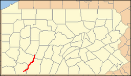
Location of Laurel Ridge State Park in Pennsylvania
|
|
| Website: Laurel Ridge State Park | |
Laurel Ridge State Park is a 13,625-acre (5,514 ha) Pennsylvania state park that passes through Cambria, Fayette, Somerset, and Westmoreland counties, Pennsylvania in the United States. The park is home to the 70-mile (110 km) Laurel Highlands Hiking Trail that runs through the park from the Youghiogheny River at Ohiopyle to the Conemaugh Gorge near Johnstown. The park was approved by the governor on July 10, 1967, and construction started on the Laurel Highlands Hiking Trail on July 7, 1970.
Laurel Highlands Hiking Trail is 70 miles (110 km) long, begins at Ohiopyle State Park and ends at Conemaugh Gorge near Johnstown. The trail goes through state forests, state parks, state game lands, and some privately owned lands. Laurel Highlands Hiking Trail is open year round. The trail is marked with yellow blazes. Connector trails are marked with blue blazes. These trails connect the main trail with parking and shelter areas. The trail is marked with large wooden signs at every major highway crossing. Six parking lots at the highway crossings provide starting points; some have access to drinking water.
There are eight overnight shelter areas on the Laurel Highlands Hiking Trail. These shelter areas are located about every 6 miles (9.7 km) to 10 miles (16 km) along the trail. The shelter areas each have five Adirondack style shelters. There are two outhouses at the rest stops and a water supply. There is room for up to 30 tents at each stop. Firewood is provided. Hikers using the shelters are required to make reservations for use of the shelters with the park staff before setting out on their hike. A fee is charged to users of the shelters.
...
Wikipedia


