Launceston (Tasmania)
|
Launceston Tasmania |
|||||||||||||||
|---|---|---|---|---|---|---|---|---|---|---|---|---|---|---|---|

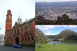
Montage of Launceston. Clockwise from left – Launceston Post Office, View of the CBD and inner suburbs from Woods Reserve and Cataract Gorge and Alexandra Suspension Bridge
|
|||||||||||||||
| Coordinates | 41°26′31″S 147°8′42″E / 41.44194°S 147.14500°ECoordinates: 41°26′31″S 147°8′42″E / 41.44194°S 147.14500°E | ||||||||||||||
| Population | 86,633 (2015) (20th) | ||||||||||||||
| • Density | 198.973/km2 (515.34/sq mi) | ||||||||||||||
| Established | 1806 | ||||||||||||||
| Postcode(s) | 7250 | ||||||||||||||
| Area | 435.4 km2 (168.1 sq mi) (2011 urban) | ||||||||||||||
| Time zone | AEST (UTC+10) | ||||||||||||||
| • Summer (DST) | AEDT (UTC+11) | ||||||||||||||
| Location |
|
||||||||||||||
| LGA(s) | City of Launceston | ||||||||||||||
| Federal Division(s) | |||||||||||||||
|
|||||||||||||||
|
|||||||||||||||
Launceston (/ˈlɒnsəstən/, often mispronounced /ˈlɔːnsəstən/) is a city in the north of Tasmania, Australia at the junction of the North Esk and South Esk rivers where they become the Tamar River (Kanamaluka). Launceston is the second largest city in Tasmania after Hobart. With a population of 86,633, Launceston is the twelfth-largest non-capital city in Australia. It is the only inland city in Tasmania.
Settled by Europeans in March 1806, Launceston is one of Australia's oldest cities and is home to many historic buildings. Like many Australian places, it was named after a town in the United Kingdom – in this case, Launceston, Cornwall. Launceston has also been home to several firsts such as the first use of anaesthetic in the Southern Hemisphere, the first Australian city to have underground sewers and the first Australian city to be lit by hydroelectricity. The city has a temperate climate with four distinct seasons. Local government is split between the City of Launceston and the Meander Valley and West Tamar Councils.
...
Wikipedia

