Lauderdale County, Tennessee
| Lauderdale County, Tennessee | |
|---|---|

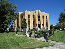
Lauderdale County Courthouse in Ripley
|
|
|
Location in the U.S. state of Tennessee |
|
 Tennessee's location in the U.S. |
|
| Founded | 1835 |
| Named for | James Lauderdale |
| Seat | Ripley |
| Largest city | Ripley |
| Area | |
| • Total | 508 sq mi (1,316 km2) |
| • Land | 472 sq mi (1,222 km2) |
| • Water | 36 sq mi (93 km2), 7.0% |
| Population (est.) | |
| • (2015) | 26,936 |
| • Density | 59/sq mi (23/km²) |
| Congressional district | 8th |
| Time zone | Central: UTC-6/-5 |
Lauderdale County is a county located on the western edge of the U.S. state of Tennessee, with its border the Mississippi River. As of the 2010 census, the population was 27,815. Its county seat is Ripley.
Lauderdale County was created in 1835 from parts of Tipton, Dyer and Haywood counties. It was named for Lieutenant Colonel James Lauderdale, who was killed at the Battle of New Orleans in the War of 1812.
In 1861, the Confederate States Army built extensive defensive fortifications in Lauderdale County along the Mississippi River and named the site for General Gideon J. Pillow. Because of its strategic location, the fort was taken over by the Union Army in 1864, which had occupied the state since 1862.
In 1864, Confederates attacked and overran the fort's defenders, who were about evenly split between white and black soldiers. As they were reported to have refused to surrender, the Confederates gave them no quarter, but killed black soldiers in twice the proportion of white ones. People in the North considered it a massacre, and blacks used the cry, "Remember Fort Pillow!" to rally during the remainder of the war.
Fort Pillow State Park is home to a museum and also has reconstructed fortifications on the original site of the fort.
According to the U.S. Census Bureau, the county has a total area of 508 square miles (1,320 km2), of which 472 square miles (1,220 km2) is land and 36 square miles (93 km2) (7.0%) is water. The county's western boundary is formed by the Mississippi River, its northern boundary with Dyer County is formed by the Forked Deer River, and its southern boundary with Haywood County is formed by the Hatchie River.
...
Wikipedia
