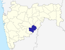
Latur district
|
Latur district लातूर जिल्हा,لاتورضلع |
|
|---|---|
| District of Maharashtra | |
 Location of Latur district in Maharashtra |
|
| Country | India |
| State | Maharashtra |
| Administrative division | Aurangabad division |
| Headquarters | Latur |
| Tehsils | 1. Latur, 2. Udgir, 3. Ahmedpur, 4. Ausa, 5. Nilanga, 6. Renapur, 7. Chakur, 8. Deoni, 9. Shirur Anantpal, 10. Jalkot. |
| Government | |
| • Lok Sabha constituencies | 2 (partial) Latur & Osmanabad |
| • Assembly seats | 6 |
| Area | |
| • Total | 7,157 km2 (2,763 sq mi) |
| Population (2011) | |
| • Total | 2,455,543 |
| • Density | 340/km2 (890/sq mi) |
| • Urban | 25.47% |
| Demographics | |
| • Literacy | 79.03% |
| • Sex ratio | 924 |
| Website | Official website |
Coordinates: 18°24′N 76°35′E / 18.4°N 76.58°E
Latur district (Marathi: लातूर जिल्हा) is a district in Maharashtra state of India. Latur city is the district headquarters and is the 16th largest city in the state of Maharashtra. The district is primarily agricultural. Urban population comprises 25.47% of the total population.
Latur has an ancient history, which probably dates to the Rashtrakuta period. It was home to a branch of Rashtrakutas which ruled the Deccan 753-973 AD. The first Rashtrakuta king Dantidurga was from Lattalur, probably the ancient name for Latur. Anecdotally, Ratnapur is mentioned as a name for Latur.
The King Amoghavarsha of Avinash developed Latur city, originally the native place of the Rashtrakutas. The Rashtrakutas who succeeded the Chalukyas of Badami in 753 AD called themselves the residents of Lattalur.
It was, over the centuries, ruled by the Satavahanas, the Sakas, the Chalukyas, the Yadavas of Deogiri, the Delhi Sultans, the Bahamani rulers of South India, Adilshahi, and the Mughals.
...
Wikipedia
