Langwies
| Langwies | ||
|---|---|---|
| Former municipality of Switzerland | ||
 |
||
|
||
| Coordinates: 46°49′N 9°43′E / 46.817°N 9.717°ECoordinates: 46°49′N 9°43′E / 46.817°N 9.717°E | ||
| Country | Switzerland | |
| Canton | Graubünden | |
| District | Plessur | |
| Area | ||
| • Total | 54.85 km2 (21.18 sq mi) | |
| Elevation | 1,377 m (4,518 ft) | |
| Population (2010) | ||
| • Total | 292 | |
| • Density | 5.3/km2 (14/sq mi) | |
| Postal code | 7057 | |
| SFOS number | 3924 | |
| Surrounded by | Arosa, Conters im Prättigau, Davos, Fideris, Klosters-Serneus, Peist | |
| Website |
www SFSO statistics |
|
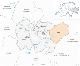
Langwies is a former municipality in the district of Plessur in the canton of Graubünden in Switzerland. On 1 January 2013 the former municipalities of Langwies, Calfreisen, Castiel, Lüen, Molinis, Peist and St. Peter-Pagig merged into the municipality of Arosa.
Langwies is first mentioned in 1384 as die lang Wise.
Before the merger, Langwies had a total area of 54.9 km2 (21.2 sq mi). Of this area, 48.8% is used for agricultural purposes, while 22.6% is forested. Of the rest of the land, 1.2% is settled (buildings or roads) and the remainder (27.5%) is non-productive (rivers, glaciers or mountains).
The former municipality is located in the Schanfigg sub-district of the Plessur district. It is located on the shortest route between Chur and Davos which is over the Strela pass. It consists of the village of Langwies and the hamlets of Platz, Litzirüti, Fondei and Sapün.
On the south-western edge of the village of Langwies, and lower down the hillside from the centre, is the Langwies railway station, on the Chur-Arosa railway line. Additionally, in the hamlet of Litzirüti is the Litzirüti railway station.
Langwies had a population (as of 2010) of 292. As of 2008[update], 6.8% of the population was made up of foreign nationals. Over the last 10 years the population has decreased at a rate of -6.1%. Most of the population (as of 2000[update]) speaks German (97.0%), with Romansh being second most common ( 0.7%) and Dutch being third ( 0.7%).
...
Wikipedia


