Lanesboro, Pennsylvania
| Lanesboro, Pennsylvania | |
|---|---|
| Borough | |

|
|
 Location of Pennsylvania in the United States |
|
| Coordinates: 41°57′48″N 75°34′55″W / 41.96333°N 75.58194°WCoordinates: 41°57′48″N 75°34′55″W / 41.96333°N 75.58194°W | |
| Country | United States |
| State | Pennsylvania |
| County | Susquehanna |
| Established | 1888 |
| Government | |
| • Mayor | Chris Maby |
| Area | |
| • Total | 2.65 sq mi (6.87 km2) |
| • Land | 2.59 sq mi (6.71 km2) |
| • Water | 0.06 sq mi (0.16 km2) |
| Population (2010) | |
| • Total | 506 |
| • Estimate (2016) | 468 |
| • Density | 180.69/sq mi (69.77/km2) |
| Time zone | EST (UTC-5) |
| • Summer (DST) | EDT (UTC-4) |
| Zip Code | 18827, 18847 |
| Area code(s) | 570 |
| FIPS code | 42-41336 |
| Website | lanesboropa |
Lanesboro is a borough in Susquehanna County, Pennsylvania, United States. The population was 506 at the 2010 census.
Lanesboro was named for Martin Lane, an early settler who first called it Lanesville. The name was changed to Lanesboro by his son Jesse Lane. Lanesboro was incorporated as a borough in 1889.
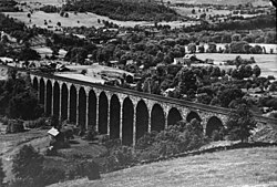
The Starrucca Viaduct was added to the National Register of Historic Places in 1975.
Lanesboro is located at 41°57′48″N 75°34′55″W / 41.96333°N 75.58194°W (41.963293, -75.582034).
According to the United States Census Bureau, the borough has a total area of 2.66 square miles (6.9 km2), of which, 2.6 square miles (6.7 km2) of it is land and 0.06 square miles (0.16 km2) of it (2.26%) is water.
As of the census of 2000, there were 588 people, 248 households, and 149 families residing in the borough. The population density was 230.6 people per square mile (89.0/km²). There were 278 housing units at an average density of 109.0 per square mile (42.1/km²). The racial makeup of the borough was 97.79% White, 0.17% Native American, 1.53% Asian, 0.17% Pacific Islander, and 0.34% from two or more races. Hispanic or Latino of any race were 0.68% of the population.
...
Wikipedia
