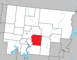
Landrienne, Quebec
| Landrienne | |
|---|---|
| Township municipality | |
 |
|
 Location within Abitibi RCM. |
|
| Location in western Quebec. | |
| Coordinates: 48°33′N 77°57′W / 48.550°N 77.950°WCoordinates: 48°33′N 77°57′W / 48.550°N 77.950°W | |
| Country |
|
| Province |
|
| Region | Abitibi-Témiscamingue |
| RCM | Abitibi |
| Settled | 1910s |
| Constituted | July 15, 1918 |
| Government | |
| • Mayor | François Lemieux |
| • Federal riding | Abitibi—Témiscamingue |
| • Prov. riding | Abitibi-Ouest |
| Area | |
| • Total | 274.90 km2 (106.14 sq mi) |
| • Land | 276.83 km2 (106.88 sq mi) |
| There is an apparent contradiction between two authoritative sources |
|
| Population (2011) | |
| • Total | 977 |
| • Density | 3.5/km2 (9/sq mi) |
| • Pop 2006-2011 |
|
| • Dwellings | 397 |
| Time zone | EST (UTC−5) |
| • Summer (DST) | EDT (UTC−4) |
| Postal code(s) | J0Y 1V0 |
| Area code(s) | 819 |
| Highways |
|
| Website | www |
Landrienne is a township municipality in the Canadian province of Quebec, located in the Abitibi Regional County Municipality. It is part of the census agglomeration of Amos.
Originally known as Saint-Barnabé-de-Landrienne, the place was named in honor of Jean-Marie Landriève Des Bordes (1712–1778), a French naval officer and Administrative Inspector.
The township had a population of 977 as of the Canada 2011 Census, and a land area of 276.83 square kilometres. Private dwellings occupied by usual residents are 379, out of 390 total dwellings. Mother tongues are:
Population trend:
...
Wikipedia

