Lancaster County, South Carolina
| Lancaster County, South Carolina | |
|---|---|

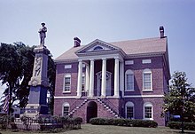
Lancaster County Courthouse
|
|
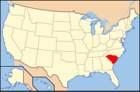
 Location in the U.S. state of South Carolina |
|
 South Carolina's location in the U.S. |
|
| Founded | 1785 |
| Seat | Lancaster |
| Largest city | Lancaster |
| Area | |
| • Total | 555 sq mi (1,437 km2) |
| • Land | 549 sq mi (1,422 km2) |
| • Water | 6.0 sq mi (16 km2), 1.1% |
| Population (est.) | |
| • (2016) | 89,594 |
| • Density | 140/sq mi (54/km²) |
| Congressional district | 5th |
| Time zone | Eastern: UTC-5/-4 |
| Website | mylancastersc |
Lancaster County /ˈleɪŋkəstər/ is a county located in the U.S. state of South Carolina. As of the 2016 census estimate, its population was 89,594. Its county seat is Lancaster which has an urban population of 23,979. The county was created in 1785.
Lancaster County is included in the Charlotte-Concord-Gastonia, NC-SC Metropolitan Statistical Area. It is located in the Piedmont region.
For hundreds of years the Catawba Indians claimed all of present Lancaster County as part of their tribal lands. The Catawba were once considered one of the most powerful Southeastern Siouan-speaking tribes. The Catawba and other Siouan peoples are believed to have coalesced as individual tribes in the Southeast. Primarily involved in agriculture, the Catawba were friendly toward early European Immigrants.
When the first White people came in the early 1750s they settled between Rum Creek and Twelve Mile Creek. Waxhaw Creek within this area had taken its name from the Waxhaw Indian tribe. The majority of the new settlers were Scots-Irish from Pennsylvania; others from North Carolina and Virginia joined them.
...
Wikipedia
