Lancaster, Kansas
| Lancaster, Kansas | |
|---|---|
| City | |

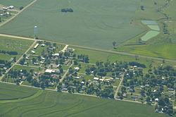
Aerial view of Lancaster (2013)
|
|
 Location within Atchison County and Kansas |
|
 KDOT map of Atchison County (legend) |
|
| Coordinates: 39°34′18″N 95°18′12″W / 39.57167°N 95.30333°WCoordinates: 39°34′18″N 95°18′12″W / 39.57167°N 95.30333°W | |
| Country | United States |
| State | Kansas |
| County | Atchison |
| Area | |
| • Total | 0.22 sq mi (0.57 km2) |
| • Land | 0.22 sq mi (0.57 km2) |
| • Water | 0 sq mi (0 km2) |
| Elevation | 1,158 ft (353 m) |
| Population (2010) | |
| • Total | 298 |
| • Estimate (2012) | 297 |
| • Density | 1,400/sq mi (520/km2) |
| Time zone | Central (CST) (UTC-6) |
| • Summer (DST) | CDT (UTC-5) |
| ZIP code | 66041 |
| Area code(s) | 913 |
| FIPS code | 20-38325 |
| GNIS feature ID | 0473483 |
Lancaster is a city in Atchison County, Kansas, in the United States. As of the 2010 census, the city population was 298.
Lancaster was platted in 1857. It may have been named after Lancaster, Pennsylvania. Lancaster was an early contender for county seat. In 1915, Lancaster contained seven stores, a school, three churches, a grain elevator, a lumber yard, and a hotel.
Lancaster was a station on the Missouri Pacific Railroad.
Lancaster is located at 39°34′18″N 95°18′12″W / 39.57167°N 95.30333°W (39.571780, -95.303344). According to the United States Census Bureau, the city has a total area of 0.22 square miles (0.57 km2), all of it land.
As of the census of 2010, there were 298 people, 108 households, and 87 families residing in the city. The population density was 1,354.5 inhabitants per square mile (523.0/km2). There were 117 housing units at an average density of 531.8 per square mile (205.3/km2). The racial makeup of the city was 98.0% White, 0.3% African American, 1.0% Native American, and 0.7% Asian.
...
Wikipedia
