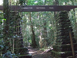
Lamington National Park
|
Lamington National Park Queensland |
|
|---|---|
|
IUCN category II (national park)
|
|

Entrance to the trail network at Binna Burra
|
|
| Nearest town or city | Canungra |
| Coordinates | 28°8′32″S 153°6′55″E / 28.14222°S 153.11528°ECoordinates: 28°8′32″S 153°6′55″E / 28.14222°S 153.11528°E |
| Established | July 1915 |
| Area | 206 km2 (79.5 sq mi) |
| Managing authorities | Queensland Parks and Wildlife Service |
| Website | Lamington National Park |
| See also | Protected areas of Queensland |
The Lamington National Park is a national park, lying on the Lamington Plateau of the McPherson Range on the Queensland/New South Wales border in Australia. From Southport on the Gold Coast the park is 85 kilometres (53 mi) to the southwest and Brisbane is 110 kilometres (68 mi) north. The 20,600 hectares (51,000 acres) Lamington National Park is known for its natural beauty, rainforests, birdlife, ancient trees, waterfalls, walking tracks and mountain views.
Protected areas to the east in Springbrook National Park and south along the Tweed Range in the Border Ranges National Park around Mount Warning in New South Wales conserve similar landscapes. The park is part of the Shield Volcano Group of the World Heritage Site Gondwana Rainforests of Australia inscribed in 1986 and added to the Australian National Heritage List in 2007. The park is part of the Scenic Rim Important Bird Area, identified as such by BirdLife International because of its importance in the conservation of several species of threatened birds.
Most of the park is situated 900 metres (3,000 ft) above sea level only 30 kilometres (19 mi) from the Pacific's ocean shores. The plateaus and cliffs in Lamington and Springbrook National Parks are the northern and north western remnants of the huge 23-million-year-old Tweed Volcano, centered around Mount Warning. Elevation in the south of the park is above 1,000 metres (3,300 ft) in some parts. The land declines to under 700 metres (2,300 ft) in the north. Some of the mountains in the park include Mount Hobwee, Mount Widgee, Mount Toolona, Mount Cominan, Mount Roberts and Mount Bithongabel, containing much of Australia's few cloud forests. The Nerang River, Albert River and Coomera River all have their source in Lamington National Park. Eastern parts of the park feature high cliffs which rise above the Numinbah Valley. The park is within the City of Gold Coast and Scenic Rim Region local government areas. Southern Lamington and sections of O'Reilly, Binna Burra and Natural Bridge are protected with Lamington National Park.
...
Wikipedia

