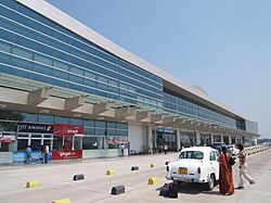
Lal Bahadur Shastri Airport
| Lal Bahadur Shastri International Airport | |||||||||||
|---|---|---|---|---|---|---|---|---|---|---|---|
 |
|||||||||||
| Summary | |||||||||||
| Airport type | Public | ||||||||||
| Operator | Airports Authority of India | ||||||||||
| Location | Varanasi, India | ||||||||||
| Elevation AMSL | 266 ft / 81 m | ||||||||||
| Coordinates | 25°27′08″N 082°51′34″E / 25.45222°N 82.85944°ECoordinates: 25°27′08″N 082°51′34″E / 25.45222°N 82.85944°E | ||||||||||
| Map | |||||||||||
| Runways | |||||||||||
|
|||||||||||
| Statistics (April 2015-March 2016) | |||||||||||
|
|||||||||||
|
Source: AAI,
|
|||||||||||
| Passenger movements | 1,839,508( |
|---|---|
| Aircraft movements | 8,801( |
| Cargo tonnage | 662( |
Lal Bahadur Shastri International Airport (IATA: VNS, ICAO: VEBN) is a public airport located at Babatpur 26 km (16 mi) northwest of Varanasi, Uttar Pradesh, India. Formerly known as Varanasi Airport, it was officially renamed after Lal Bahadur Shastri in October 2005.
The airport was granted international status by the Union Cabinet on 4 October 2012.
...
Wikipedia


