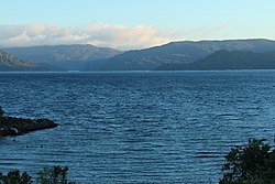
Lake Waikaremoana
| Lake Waikaremoana | |
|---|---|

Lake Waikaremoana (winter 2015)
|
|

Location
|
|
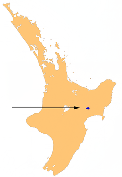
| Location | Wairoa District, Hawke's Bay Region, North Island |
| Coordinates | 38°46′S 177°05′E / 38.767°S 177.083°ECoordinates: 38°46′S 177°05′E / 38.767°S 177.083°E |
| Primary outflows | Waikaretaheke River |
| Basin countries | New Zealand |
| Surface area | 54 km2 (21 sq mi) |
| Max. depth | 256 m (840 ft) |
| Shore length1 | 102.3 km (63.6 mi) |
| Surface elevation | 600 m (2,000 ft) |
| Settlements | Āniwaniwa |
| 1 Shore length is not a well-defined measure. | |
Lake Waikaremoana is located in Te Urewera in the North Island of New Zealand, 60 kilometres northwest of Wairoa and 80 kilometres west-southwest of Gisborne. It covers an area of 54 km2 (21 sq mi). From the Maori Waikaremoana translates as 'sea of rippling waters'
The lake lies in the heart of Tuhoe country. The hamlet of Āniwaniwa and the Waikaremoana Holiday Park are located on the lakeshore, along SH38 (from Wai-O-Tapu via Murupara to Wairoa), which connects the lake to the central North Island (Rotorua) and Gisborne. There is a Department of Conservation office at Aniwaniwa. Several walks start here, including a short stroll to Aniwaniwa Falls.
Lake Waikaremoana is a holiday destination for people who use the lake for fishing, tramping and other recreational activities. The Lake Waikaremoana Track, one of New Zealand's "Great Walks", is a three- to four-day tramp which follows approximately half of the lake's circumference. The track can be walked independently, or as part of a guided group. There are huts dotted on the walk which require booking to use. Camping is permitted unless you are more than 500 metres from the track.
The climate of the area is temperate In the summer and cool during the winters, snowfalls occur a few times a year in the region.
Numbers of visitors to the area are limited to some extent as a result of the extensive unsealed road that must be taken to reach it. This makes Lake Waikaremoana significantly less congested with tourists than the other 8 Great Walks in New Zealand. The smaller Lake Waikareiti lies four kilometres to the northeast.
Waikaremoana, the North Island's deepest lake (256 m deep), has its surface at 600 metres above sea level. A huge landslide dam about 250 metres high formed the lake around 2,200 years ago. Before the landslip was sealed, around 1950, much of the lake outflow flowed through the landslip rather than out of an overflow at a low point in the slip.
...
Wikipedia
