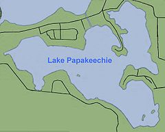
Lake Papakeechie
| Lake Papakeechie | |
|---|---|

Diagram of Lake Papakeechie
|
|
| Location | Kosciusko County, Indiana |
| Coordinates | 41°22′21″N 85°40′13″W / 41.3726°N 85.6702°WCoordinates: 41°22′21″N 85°40′13″W / 41.3726°N 85.6702°W |
| Type | reservoir |
| Catchment area | 5.36 sq mi (13.9 km2) |
| Basin countries | United States |
| Surface area | 179 acres (0.72 km2) |
| Surface elevation | 863 feet (263 m) |
Lake Papakeechie is a small man-made lake of 179 acres (0.72 km²) located in Kosciusko County, Indiana, United States. The lake is situated south of and drains into Lake Wawasee. The lake is owned by the Papakeechie Protective Association.
Lake Papakeechie is named after Miami chief Papakeecha or Pa-hed-ke-teh-a, the most influential chief in the region around Lake Wawasee.
Papakeechie was created just before 1910 in the same location and in a basin where six small lakes once occupied this area. The small lakes were named Jarret's, Gan's, Hooper's and three named Hartzell's. Early in the 19th century a fish trap or fish weir was constructed at the outlet where water flowed to Lake Wawasee where settlers would easily catch fish. The lake (with dam) was deemed completed in 1913.
When an 8 foot (2.4 m) earthen dam was constructed by Charles A. Sudlow of Indianapolis on that north side, the water level rose elevating large masses of vegetation. These were loaded with rocks and filled with holes and sunk to the bottom.
A 1931 Syracuse Chamber of Commerce booklet shows 69 homes on the lake. Today, there are close to 400 houses around the lake, 300 of those on the lake front. There are still a few undeveloped lots owned by individuals adjacent to existing property and a wedge of wooded area. The lots, 50 feet (15 m) wide with various depths, were sold for $500 each. The 5 miles (8.0 km) of shoreline was known as “good for fishing.” The booklet, possibly used as a sales tool, provided the legend, topography, history, information about the hatcheries, the corporation and approaches, complete with photos of the various areas and survey of the property.
The Legend The legend states three small tribes of the Great Potowattamie family often settled around the largest lake in the region. The largest and most powerful tribe occupied Conklin Hill, overlooking the lake from the west and their chieftain's name was “Wawasee.” Chief Flatbelly took his people to the peninsula on the north which now bears his name, “while the finest and bravest young chieftain of them all, having the smallest tribe, was obliged to settle on the hills and fish in the little lakes that lay adjacent to the big one, on the south.” When a map of the region was made, it was seen two lakes formed a turkey with a monstrous head with the streams as whiskers. Thus the original name of Turkey Lake.
...
Wikipedia
