Lake Oroville
| Lake Oroville | |
|---|---|

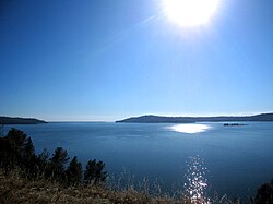
View looking South over main basin area of Lake Oroville, towards Oroville Dam, seen at center left.
|
|
| Location | Oroville East, Butte County, California |
| Coordinates | 39°32′14″N 121°29′00″W / 39.53722°N 121.48333°WCoordinates: 39°32′14″N 121°29′00″W / 39.53722°N 121.48333°W at Oroville Dam |
| Lake type | Reservoir |
| Primary inflows | North Fork Feather River, Middle Fork Feather River, West Branch Feather River, South Fork Feather River, various other smaller streams |
| Primary outflows | Feather River |
| Catchment area | 3,950 square miles (10,200 km2) |
| Basin countries | United States |
| Built | 1961 (Construction started on Oroville Dam) |
| First flooded | 1969 |
| Water volume | 3,537,577 acre feet (4.363537×10⁹ m3) |
| Shore length1 | 167 miles (269 km) |
| Surface elevation | 901 feet (275 m) |
| Frozen | Never |
| Islands | Bloomer Island, Foreman Island, others unnamed |
| Settlements | Oroville |
| 1 Shore length is not a well-defined measure. | |
Lake Oroville is a reservoir formed by the Oroville Dam impounding the Feather River, located in Butte County, northern California. The lake is situated 5 miles (8.0 km) northeast of the city of Oroville, within the Lake Oroville State Recreation Area, in the western foothills of the Sierra Nevada. Known as the second-largest reservoir in California, Lake Oroville is treated as a keystone facility within the California State Water Project by storing water, providing flood control, recreation, freshwater releases assist in controlling the salinity intrusion Sacramento-San Joaquin Delta and protecting fish and wildlife.
The lake is a popular nationally renowned bass fishing location, while coho salmon are stocked from the Feather River Fish Hatchery. This hatchery is a main component of Lake Oroville.
The local indigenous tribe were the Konkow Maidu (translation is 'man') who originally settled the lake region and Feather River for many years. Today many of the small towns including Oroville were originally occupied by the Maidu people. In 2002, a Sonoma State study took archaeological inventory of the 15,476 acres (6,263 ha) of Lake Oroville to learn 250 sites are from the prehistoric era relating to the Native American life along the Feather River and an additional 478 sites dating to the Gold Rush. These sites included open-air residential sites, caves and rockshelters, limited lithic scatters, rock art, quarries and workshops, bedrock milling sites and cemetery areas. Natives lives were disrupted by gold discovery in 1848 and the white miners infiltrated their lands. In April 1848, only three months after gold was discovered at Sutter's Mill, John Bidwell found gold on the Feather River at a spot known today as the town of Bidwell Bar. Bidwell began to work the claim using local Konkow Maidu workers, due to the rapid spreading news of the California strikes under a year California's non-native population climbed from 20,000 to 100,000 and by 1850 Butte County alone supported 3,052 miners.
...
Wikipedia
